Salbertrand geodata
Salbertrand (Piedmont) is a seat of a third-order administrative division; located in Italy in Europe/Rome (GMT+2) time zone. With population of 467 people, there are 10030 cities with bigger population in this country. Compared to other cities in Italy, 61.8% of cities are located further ↓South; 99.9% of cities are located further →East and 97.1% of cities have lower elevation than Salbertrand. Note1


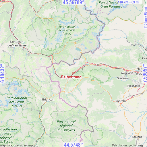
Salbertrand GPS coordinates[2]
45° 4' 24.6" North, 6° 53' 14.784" East
| Map corner | latitude | longitude |
|---|---|---|
| Upper-left | 45.56789°, | 6.18432° |
| Center: | 45.0735°, | 6.88744° |
| Lower-right: | 44.5748°, | 7.59057° |
| Map W x H: | 110.4×110.4 km | = 68.6×68.6mi |
| max Lat: | 47.04031° ⇑38.2% North |
| Salbertrand: | 45.0735° |
| min Lat: | ⇓61.8% South 35.50142° |
| min Long | Salbertrand | max Long |
| 6.69888° | 6.88744° | 18.48682° |
| W 0.1%⇐ | ⇒99.9% E |
Elevation
Elevation of Salbertrand is 1006 m = 3301 ft, and this is 699.3 m = 2294 ft above average elevation for this country.
| Max E: |
2085 m = 6841 ft | 2.9% |
| Salbertrand | 1006 m 3301 ft | |
| Avg. | 306.7 m = 1006 ft | |
Min E: |
-4 m = -13 ft | 97.1% |
See also: Italy elevation on elevation.city.
Geographical zone
Salbertrand is located in North temperate zone (between Tropic of Cancer and the Arctic Circle). Distance of this North polar circle is 2389.5 km =1484.8 mi to North.| Distance of | km | miles | from Salbertrand |
|---|---|---|---|
| North Pole | 4995.4 | 3104 | to North |
| Arctic Circle | 2389.5 | 1484.8 | to North |
| Tropic Cancer | 2405.8 | 1494.9 | to South |
| Equator | 5011.7 | 3114.1 | to South |


Nearby cities:
15 places around Salbertrand: (largest is in red/bold)
• Bardonecchia
14.8 km =9.2 mi,  270°
270°
• Chiomonte
9.1 km =5.7 mi,  56°
56°
• Colle Sestriere
12.9 km =8 mi,  183°
183°
• Exilles
4.2 km =2.6 mi,  50°
50°
• Fenestrelle
13.4 km =8.3 mi,  108°
108°
• Giaglione
12.4 km =7.7 mi, 53°
• Gravere
11.7 km =7.3 mi, 60°
• Mompantero
14.7 km =9.1 mi, 56°
• Oulx
5.9 km =3.7 mi,  225°
225°
• Pragelato-Ruà
7.9 km =4.9 mi,  147°
147°
• San Giuseppe
14.7 km =9.1 mi, 56°
• Sauze d'Oulx
5.6 km =3.5 mi,  201°
201°
• Sestriere
12.8 km =8 mi, 183°
• Usseaux
11.4 km =7.1 mi,  103°
103°
• Venaus
13.4 km =8.3 mi, 46°
Sources, notices
• [Note1] Compared only with cities in Italy existing in our database
• [Src1] Map data: © OpenStreetMap contributors (CC-BY-SA)
• [Src2] Other city data from geonames.org with taken over terms of usage.
• [Src3] Geographical zone / Annual Mean Temperature by Robert A. Rohde @ Wikipedia
