Perrero geodata
Perrero (Piedmont) is a seat of a third-order administrative division; located in Italy in Europe/Rome (GMT+2) time zone. With population of 243 people, there are 10928 cities with bigger population in this country. Compared to other cities in Italy, 58.6% of cities are located further ↓South; 99.6% of cities are located further →East and 93.5% of cities have lower elevation than Perrero. Note1


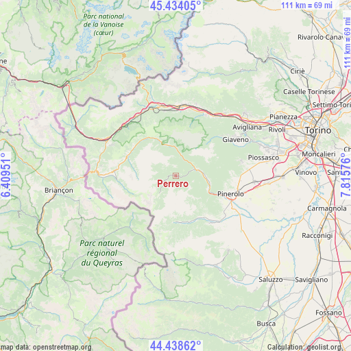
Perrero GPS coordinates[2]
44° 56' 18.564" North, 7° 6' 45.468" East
| Map corner | latitude | longitude |
|---|---|---|
| Upper-left | 45.43405°, | 6.40951° |
| Center: | 44.93849°, | 7.11263° |
| Lower-right: | 44.43862°, | 7.81576° |
| Map W x H: | 110.7×110.7 km | = 68.8×68.8mi |
| max Lat: | 47.04031° ⇑41.4% North |
| Perrero: | 44.93849° |
| min Lat: | ⇓58.6% South 35.50142° |
| min Long | Perrero | max Long |
| 6.69888° | 7.11263° | 18.48682° |
| W 0.4%⇐ | ⇒99.6% E |
Elevation
Elevation of Perrero is 817 m = 2680 ft, and this is 510.3 m = 1674 ft above average elevation for this country.
| Max E: |
2085 m = 6841 ft | 6.5% |
| Perrero | 817 m 2680 ft | |
| Avg. | 306.7 m = 1006 ft | |
Min E: |
-4 m = -13 ft | 93.5% |
See also: Italy elevation on elevation.city.
Geographical zone
Perrero is located in North temperate zone (between Tropic of Cancer and the Arctic Circle). Distance of this Northern Tropic circle is 2390.8 km =1485.6 mi to South.| Distance of | km | miles | from Perrero |
|---|---|---|---|
| North Pole | 5010.4 | 3113.3 | to North |
| Arctic Circle | 2404.5 | 1494.1 | to North |
| Tropic Cancer | 2390.8 | 1485.6 | to South |
| Equator | 4996.7 | 3104.8 | to South |


Nearby cities:
15 places around Perrero: (largest is in red/bold)
• Angrogna
13.7 km =8.5 mi,  140°
140°
• Fenestrelle
11.9 km =7.4 mi,  335°
335°
• Fleccia-Chianavasso
8.1 km =5 mi,  83°
83°
• Inverso Pinasca
8.4 km =5.2 mi, 84°
• Massello
4.9 km =3 mi,  297°
297°
• Perosa Argentina
6.6 km =4.1 mi,  69°
69°
• Pinasca-Dubbione
9.2 km =5.7 mi,  87°
87°
• Pomaretto
5.7 km =3.5 mi, 70°
• Porte
13.6 km =8.5 mi,  114°
114°
• Prali
7.3 km =4.5 mi,  221°
221°
• Pramollo
7 km =4.3 mi,  118°
118°
• Roure
7.2 km =4.5 mi,  11°
11°
• Salza di Pinerolo
4.7 km =2.9 mi,  272°
272°
• San Germano Chisone
10.6 km =6.6 mi, 112°
• Villar Perosa
10.9 km =6.8 mi,  101°
101°
Sources, notices
• [Note1] Compared only with cities in Italy existing in our database
• [Src1] Map data: © OpenStreetMap contributors (CC-BY-SA)
• [Src2] Other city data from geonames.org with taken over terms of usage.
• [Src3] Geographical zone / Annual Mean Temperature by Robert A. Rohde @ Wikipedia
