Serravalle Pistoiese geodata
Serravalle Pistoiese (Tuscany) is a seat of a third-order administrative division; located in Italy in Europe/Rome (GMT+2) time zone. With population of 258 people, there are 10856 cities with bigger population in this country. Compared to other cities in Italy, 55.7% of cities are located further ↑North; 59.4% of cities are located further →East and 58.4% of cities have higher elevation than Serravalle Pistoiese. Note1
Administrative division(s):
- Level 1: Tuscany
- Level 2: Provincia di Pistoia
- Level 3: Serravalle Pistoiese
Current local time in Serravalle Pistoiese:
08:04 PM, WednesdayDifference from your time zone: hours


Serravalle Pistoiese GPS coordinates[2]
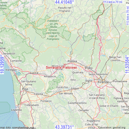
43° 54' 21.78" North, 10° 49' 57.756" East
| Map corner | latitude | longitude |
|---|---|---|
| Upper-left | 44.41048°, | 10.12959° |
| Center: | 43.90605°, | 10.83271° |
| Lower-right: | 43.39731°, | 11.53584° |
| Map W x H: | 112.7×112.7 km | = 70×70mi |
| max Lat: | 47.04031° ⇑55.7% North |
| Serravalle Pistoiese: | 43.90605° |
| min Lat: | ⇓44.3% South 35.50142° |
| min Long | Serravalle Pist | max Long |
| 6.69888° | 10.83271° | 18.48682° |
| W 40.6%⇐ | ⇒59.4% E |
Elevation
Elevation of Serravalle Pistoiese is 176 m = 577 ft, and this is 130.7 m = 429 ft below average elevation for this country.
| Max E: |
2085 m = 6841 ft | 58.4% |
| Avg. | 306.7 m = 1006 ft | |
| Serravalle Pistoiese | 176 m = 577 ft | |
Min E: |
-4 m = -13 ft | 41.6% |
See also: Italy elevation on elevation.city.
Geographical zone
Serravalle Pistoiese is located in North temperate zone (between Tropic of Cancer and the Arctic Circle). Distance of this Northern Tropic circle is 2276 km =1414.2 mi to South.| Distance of | km | miles | from Serravalle Pistoiese |
|---|---|---|---|
| North Pole | 5125.2 | 3184.7 | to North |
| Arctic Circle | 2519.3 | 1565.4 | to North |
| Tropic Cancer | 2276 | 1414.2 | to South |
| Equator | 4881.9 | 3033.5 | to South |


Nearby cities:
15 places around Serravalle Pistoiese: (largest is in red/bold)
• Borgo a Buggiano
8.6 km =5.3 mi,  246°
246°
• Cantagrillo-Casalguidi
7.7 km =4.8 mi,  122°
122°
• Cintolese
6.7 km =4.2 mi,  184°
184°
• Larciano
9.3 km =5.8 mi,  150°
150°
• Margine Coperta-Traversagna
6.7 km =4.2 mi,  244°
244°
• Marliana
5.9 km =3.7 mi,  301°
301°
• Massa
7.1 km =4.4 mi,  272°
272°
• Monsummano Terme
4.6 km =2.9 mi,  200°
200°
• Montecatini-Terme
5.6 km =3.5 mi, 240°
• Pieve a Nievole
3.8 km =2.4 mi,  223°
223°
• Pistoia
7.8 km =4.8 mi,  69°
69°
• Ponte di Serravalle
1.4 km =0.9 mi, 217°
• Pozzarello
5.4 km =3.4 mi, 179°
• Stazione Masotti
1.7 km =1.1 mi,  76°
76°
• Uggia-Pazzera-Bizzarrino
8 km =5 mi, 180°
Sources, notices
• [Note1] Compared only with cities in Italy existing in our database
• [Src1] Map data: © OpenStreetMap contributors (CC-BY-SA)
• [Src2] Other city data from geonames.org with taken over terms of usage.
• [Src3] Geographical zone / Annual Mean Temperature by Robert A. Rohde @ Wikipedia
