Pistoia geodata
Pistoia (Tuscany) is a seat of a second-order administrative division; located in Italy in Europe/Rome (GMT+2) time zone. With population of 73,832 people, there are 67 cities with bigger population in this country. Compared to other cities in Italy, 55.4% of cities are located further ↑North; 58.2% of cities are located further →East and 77.2% of cities have higher elevation than Pistoia. Note1


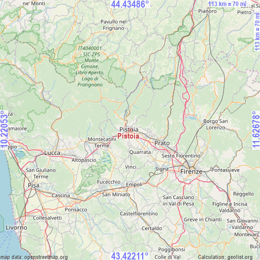
Pistoia GPS coordinates[2]
43° 55' 50.304" North, 10° 55' 25.14" East
| Map corner | latitude | longitude |
|---|---|---|
| Upper-left | 44.43486°, | 10.22053° |
| Center: | 43.93064°, | 10.92365° |
| Lower-right: | 43.42211°, | 11.62678° |
| Map W x H: | 112.6×112.6 km | = 70×70mi |
| max Lat: | 47.04031° ⇑55.4% North |
| Pistoia: | 43.93064° |
| min Lat: | ⇓44.6% South 35.50142° |
| min Long | Pistoia | max Long |
| 6.69888° | 10.92365° | 18.48682° |
| W 41.8%⇐ | ⇒58.2% E |
Elevation
Elevation of Pistoia is 63 m = 207 ft, and this is 243.7 m = 800 ft below average elevation for this country.
| Max E: |
2085 m = 6841 ft | 77.2% |
| Avg. | 306.7 m = 1006 ft | |
| Pistoia | 63 m = 207 ft | |
Min E: |
-4 m = -13 ft | 22.8% |
See also: Pistoia elevation on elevation.city.
Geographical zone
Pistoia is located in North temperate zone (between Tropic of Cancer and the Arctic Circle). Distance of this Northern Tropic circle is 2278.7 km =1415.9 mi to South.| Distance of | km | miles | from Pistoia |
|---|---|---|---|
| North Pole | 5122.4 | 3182.9 | to North |
| Arctic Circle | 2516.5 | 1563.7 | to North |
| Tropic Cancer | 2278.7 | 1415.9 | to South |
| Equator | 4884.6 | 3035.1 | to South |


Nearby cities:
15 places around Pistoia: (largest is in red/bold)
• Agliana
7.3 km =4.5 mi,  115°
115°
• Barba
6.8 km =4.2 mi,  141°
141°
• Cantagrillo-Casalguidi
6.9 km =4.3 mi,  186°
186°
• Cireglio
8.8 km =5.5 mi,  321°
321°
• Fornacelle
9 km =5.6 mi,  94°
94°
• Montale
7.5 km =4.7 mi, 86°
• Montemurlo
9.1 km =5.7 mi, 92°
• Ponte di Serravalle
9 km =5.6 mi,  244°
244°
• Ponzano
5 km =3.1 mi,  39°
39°
• Santonuovo
7.5 km =4.7 mi,  167°
167°
• Serravalle Pistoiese
7.8 km =4.8 mi,  249°
249°
• Stazione
7.5 km =4.7 mi,  103°
103°
• Stazione Masotti
6 km =3.7 mi, 247°
• Valenzatico
7.8 km =4.8 mi,  154°
154°
• Vignole-Olmi
8.9 km =5.5 mi, 142°
Sources, notices
• [Note1] Compared only with cities in Italy existing in our database
• [Src1] Map data: © OpenStreetMap contributors (CC-BY-SA)
• [Src2] Other city data from geonames.org with taken over terms of usage.
• [Src3] Geographical zone / Annual Mean Temperature by Robert A. Rohde @ Wikipedia
