Segrate geodata
Segrate (Lombardy) is a seat of a third-order administrative division; located in Italy in Europe/Rome (GMT+2) time zone. With population of 28,296 people, there are 289 cities with bigger population in this country. Compared to other cities in Italy, 73.3% of cities are located further ↓South; 76.4% of cities are located further →East and 66.2% of cities have higher elevation than Segrate. Note1
Administrative division(s):
- Level 1: Lombardy
- Level 2: Città metropolitana di Milano
- Level 3: Segrate


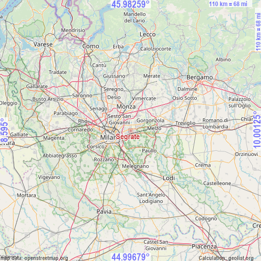
Segrate GPS coordinates[2]
45° 29' 30.66" North, 9° 17' 53.232" East
| Map corner | latitude | longitude |
|---|---|---|
| Upper-left | 45.98259°, | 8.595° |
| Center: | 45.49185°, | 9.29812° |
| Lower-right: | 44.99679°, | 10.00125° |
| Map W x H: | 109.6×109.6 km | = 68.1×68.1mi |
| max Lat: | 47.04031° ⇑26.7% North |
| Segrate: | 45.49185° |
| min Lat: | ⇓73.3% South 35.50142° |
| min Long | Segrate | max Long |
| 6.69888° | 9.29812° | 18.48682° |
| W 23.6%⇐ | ⇒76.4% E |
Elevation
Elevation of Segrate is 120 m = 394 ft, and this is 186.7 m = 613 ft below average elevation for this country.
| Max E: |
2085 m = 6841 ft | 66.2% |
| Avg. | 306.7 m = 1006 ft | |
| Segrate | 120 m = 394 ft | |
Min E: |
-4 m = -13 ft | 33.8% |
See also: Italy elevation on elevation.city.
Geographical zone
Segrate is located in North temperate zone (between Tropic of Cancer and the Arctic Circle). Distance of this North polar circle is 2343 km =1455.9 mi to North.| Distance of | km | miles | from Segrate |
|---|---|---|---|
| North Pole | 4948.8 | 3075 | to North |
| Arctic Circle | 2343 | 1455.9 | to North |
| Tropic Cancer | 2452.3 | 1523.8 | to South |
| Equator | 5058.2 | 3143 | to South |


Nearby cities:
15 places around Segrate: (largest is in red/bold)
• Bettola-Zeloforomagno
6.8 km =4.2 mi,  173°
173°
• Brugherio
6.8 km =4.2 mi,  0°
0°
• Cassina de' Pecchi
5.5 km =3.4 mi,  60°
60°
• Cernusco sul Naviglio
4.6 km =2.9 mi,  36°
36°
• Cologno Monzese
4.5 km =2.8 mi,  339°
339°
• Linate
5.4 km =3.4 mi,  201°
201°
• Lucino-Rodano
4.6 km =2.9 mi,  112°
112°
• Mezzate
5.3 km =3.3 mi,  183°
183°
• Millepini
3.9 km =2.4 mi,  128°
128°
• Novegro-Tregarezzo-San Felice
3 km =1.9 mi,  206°
206°
• Pioltello
2.7 km =1.7 mi,  67°
67°
• Ronco
6.1 km =3.8 mi,  50°
50°
• San Bovio-San Felice
3.4 km =2.1 mi,  160°
160°
• Vignate
6.2 km =3.9 mi,  82°
82°
• Vimodrone
2.7 km =1.7 mi, 342°
Sources, notices
• [Note1] Compared only with cities in Italy existing in our database
• [Src1] Map data: © OpenStreetMap contributors (CC-BY-SA)
• [Src2] Other city data from geonames.org with taken over terms of usage.
• [Src3] Geographical zone / Annual Mean Temperature by Robert A. Rohde @ Wikipedia
