Bettola-Zeloforomagno geodata
Bettola-Zeloforomagno (Lombardy) is a seat of a third-order administrative division; located in Italy in Europe/Rome (GMT+2) time zone. With population of 13,761 people, there are 659 cities with bigger population in this country. Compared to other cities in Italy, 71.3% of cities are located further ↓South; 76.2% of cities are located further →East and 68.5% of cities have higher elevation than Bettola-Zeloforomagno. Note1
Administrative division(s):
- Level 1: Lombardy
- Level 2: Città metropolitana di Milano
- Level 3: Peschiera Borromeo
Current local time in Bettola-Zeloforomagno:
08:25 PM, WednesdayDifference from your time zone: hours


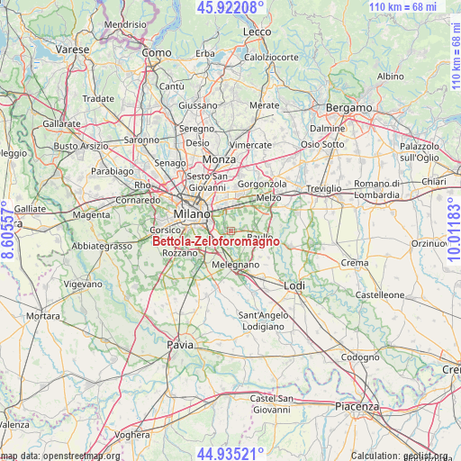
Bettola-Zeloforomagno GPS coordinates[2]
45° 25' 50.88" North, 9° 18' 31.32" East
| Map corner | latitude | longitude |
|---|---|---|
| Upper-left | 45.92208°, | 8.60557° |
| Center: | 45.4308°, | 9.3087° |
| Lower-right: | 44.93521°, | 10.01183° |
| Map W x H: | 109.7×109.7 km | = 68.2×68.2mi |
| max Lat: | 47.04031° ⇑28.7% North |
| Bettola-Zeloforomagno: | 45.4308° |
| min Lat: | ⇓71.3% South 35.50142° |
| min Long | Bettola-Zelofor | max Long |
| 6.69888° | 9.3087° | 18.48682° |
| W 23.8%⇐ | ⇒76.2% E |
Elevation
Elevation of Bettola-Zeloforomagno is 106 m = 348 ft, and this is 200.7 m = 658 ft below average elevation for this country.
| Max E: |
2085 m = 6841 ft | 68.5% |
| Avg. | 306.7 m = 1006 ft | |
| Bettola-Zeloforomagno | 106 m = 348 ft | |
Min E: |
-4 m = -13 ft | 31.5% |
See also: Italy elevation on elevation.city.
Geographical zone
Bettola-Zeloforomagno is located in North temperate zone (between Tropic of Cancer and the Arctic Circle). Distance of this North polar circle is 2349.7 km =1460 mi to North.| Distance of | km | miles | from Bettola-Zeloforomagno |
|---|---|---|---|
| North Pole | 4955.6 | 3079.3 | to North |
| Arctic Circle | 2349.7 | 1460 | to North |
| Tropic Cancer | 2445.5 | 1519.6 | to South |
| Equator | 5051.4 | 3138.8 | to South |


Nearby cities:
15 places around Bettola-Zeloforomagno: (largest is in red/bold)
• Bustighera
4.3 km =2.7 mi,  142°
142°
• Civesio
5.1 km =3.2 mi,  219°
219°
• Linate
3.4 km =2.1 mi,  302°
302°
• Mediglia
4.3 km =2.7 mi,  155°
155°
• Mezzate
1.8 km =1.1 mi,  322°
322°
• Millepini
4.9 km =3 mi,  27°
27°
• Mombretto
4.5 km =2.8 mi,  99°
99°
• Novegro-Tregarezzo-San Felice
4.6 km =2.9 mi,  332°
332°
• Pantigliate
3.4 km =2.1 mi,  81°
81°
• Robbiano
1.4 km =0.9 mi,  176°
176°
• San Bovio-San Felice
3.6 km =2.2 mi,  4°
4°
• San Donato Milanese
3.9 km =2.4 mi,  234°
234°
• San Giuliano Milanese
4.3 km =2.7 mi,  198°
198°
• Triginto
3.4 km =2.1 mi, 158°
• Vigliano-Bettolino
2.8 km =1.7 mi,  85°
85°
Sources, notices
• [Note1] Compared only with cities in Italy existing in our database
• [Src1] Map data: © OpenStreetMap contributors (CC-BY-SA)
• [Src2] Other city data from geonames.org with taken over terms of usage.
• [Src3] Geographical zone / Annual Mean Temperature by Robert A. Rohde @ Wikipedia
