Sedrano geodata
Sedrano (Friuli Venezia Giulia) is a populated place; located in Italy in Europe/Rome (GMT+2) time zone. With population of 531 people, there are 9636 cities with bigger population in this country. Compared to other cities in Italy, 93.1% of cities are located further ↓South; 64.5% of cities are located further ←West and 62.6% of cities have higher elevation than Sedrano. Note1
Administrative division(s):
- Level 1: Friuli Venezia Giulia
- Level 2: Provincia di Pordenone
- Level 3: San Quirino


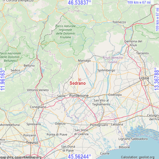
Sedrano GPS coordinates[2]
46° 3' 9.216" North, 12° 39' 53.1" East
| Map corner | latitude | longitude |
|---|---|---|
| Upper-left | 46.53837°, | 11.96163° |
| Center: | 46.05256°, | 12.66475° |
| Lower-right: | 45.56244°, | 13.36788° |
| Map W x H: | 108.5×108.5 km | = 67.4×67.4mi |
| max Lat: | 47.04031° ⇑6.9% North |
| Sedrano: | 46.05256° |
| min Lat: | ⇓93.1% South 35.50142° |
| min Long | Sedrano | max Long |
| 6.69888° | 12.66475° | 18.48682° |
| W 64.5%⇐ | ⇒35.5% E |
Elevation
Elevation of Sedrano is 144 m = 472 ft, and this is 162.7 m = 534 ft below average elevation for this country.
| Max E: |
2085 m = 6841 ft | 62.6% |
| Avg. | 306.7 m = 1006 ft | |
| Sedrano | 144 m = 472 ft | |
Min E: |
-4 m = -13 ft | 37.4% |
See also: Italy elevation on elevation.city.
Geographical zone
Sedrano is located in North temperate zone (between Tropic of Cancer and the Arctic Circle). Distance of this North polar circle is 2280.6 km =1417.1 mi to North.| Distance of | km | miles | from Sedrano |
|---|---|---|---|
| North Pole | 4886.5 | 3036.3 | to North |
| Arctic Circle | 2280.6 | 1417.1 | to North |
| Tropic Cancer | 2514.6 | 1562.5 | to South |
| Equator | 5120.6 | 3181.8 | to South |


Nearby cities:
15 places around Sedrano: (largest is in red/bold)
• Aviano
5.8 km =3.6 mi,  290°
290°
• Aviano-Castello
6.5 km =4 mi,  284°
284°
• Budoia
10.1 km =6.3 mi,  264°
264°
• Ceolini
8.4 km =5.2 mi,  215°
215°
• Cordenons
8.1 km =5 mi,  160°
160°
• Giais
8.4 km =5.2 mi,  329°
329°
• Marsure
7.1 km =4.4 mi,  310°
310°
• Musil
9.6 km =6 mi,  165°
165°
• Roveredo in Piano
6 km =3.7 mi, 215°
• San Foca
2.4 km =1.5 mi,  72°
72°
• San Leonardo
5.2 km =3.2 mi,  15°
15°
• San Martino Di Campagna
2.4 km =1.5 mi,  336°
336°
• San Quirino
2.3 km =1.4 mi,  152°
152°
• Villa D'Arco
5.9 km =3.7 mi,  179°
179°
• Vivaro
9.2 km =5.7 mi, 73°
Sources, notices
• [Note1] Compared only with cities in Italy existing in our database
• [Src1] Map data: © OpenStreetMap contributors (CC-BY-SA)
• [Src2] Other city data from geonames.org with taken over terms of usage.
• [Src3] Geographical zone / Annual Mean Temperature by Robert A. Rohde @ Wikipedia
