Scerne geodata
Scerne (Abruzzo) is a populated place; located in Italy in Europe/Rome (GMT+2) time zone. With population of 1,982 people, there are 4191 cities with bigger population in this country. Compared to other cities in Italy, 65.5% of cities are located further ↑North; 78.4% of cities are located further ←West and 97.2% of cities have higher elevation than Scerne. Note1


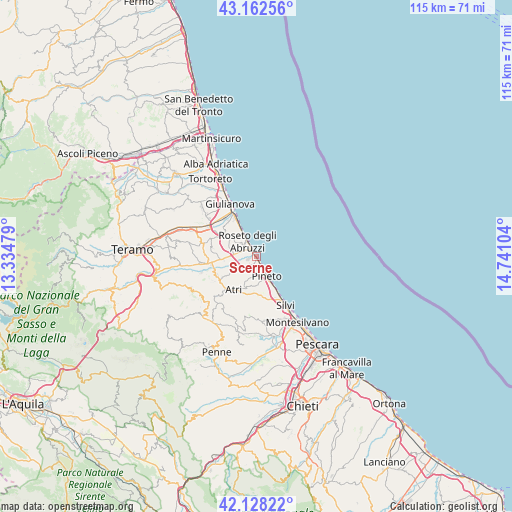
Scerne GPS coordinates[2]
42° 38' 51.144" North, 14° 2' 16.476" East
| Map corner | latitude | longitude |
|---|---|---|
| Upper-left | 43.16256°, | 13.33479° |
| Center: | 42.64754°, | 14.03791° |
| Lower-right: | 42.12822°, | 14.74104° |
| Map W x H: | 115×115 km | = 71.5×71.5mi |
| max Lat: | 47.04031° ⇑65.5% North |
| Scerne: | 42.64754° |
| min Lat: | ⇓34.5% South 35.50142° |
| min Long | Scerne | max Long |
| 6.69888° | 14.03791° | 18.48682° |
| W 78.4%⇐ | ⇒21.6% E |
Elevation
Elevation of Scerne is 5 m = 16 ft, and this is 301.7 m = 990 ft below average elevation for this country.
| Max E: |
2085 m = 6841 ft | 97.2% |
| Avg. | 306.7 m = 1006 ft | |
| Scerne | 5 m = 16 ft | |
Min E: |
-4 m = -13 ft | 2.8% |
See also: Italy elevation on elevation.city.
Geographical zone
Scerne is located in North temperate zone (between Tropic of Cancer and the Arctic Circle). Distance of this Northern Tropic circle is 2136 km =1327.2 mi to South.| Distance of | km | miles | from Scerne |
|---|---|---|---|
| North Pole | 5265.1 | 3271.6 | to North |
| Arctic Circle | 2659.2 | 1652.3 | to North |
| Tropic Cancer | 2136 | 1327.2 | to South |
| Equator | 4742 | 2946.5 | to South |


Nearby cities:
15 places around Scerne: (largest is in red/bold)
• Atri
8.9 km =5.5 mi,  206°
206°
• Borgo Santa Maria Immacolata
4 km =2.5 mi,  171°
171°
• Casoli
5.9 km =3.7 mi,  234°
234°
• Cologna Paese
8.9 km =5.5 mi,  305°
305°
• Cologna Spiaggia
9.4 km =5.8 mi,  331°
331°
• Montepagano
5.1 km =3.2 mi, 309°
• Morro d'Oro
9.7 km =6 mi,  280°
280°
• Mutignano
6.6 km =4.1 mi,  182°
182°
• Pagliare
7.1 km =4.4 mi,  266°
266°
• Pineto
4.9 km =3 mi,  151°
151°
• Roseto degli Abruzzi
3.3 km =2.1 mi,  324°
324°
• San Giovanni
4.3 km =2.7 mi, 279°
• Santa Lucia
6.1 km =3.8 mi, 268°
• Santa Maria a Valle
7 km =4.3 mi, 150°
• Zona P.E.E.P.
4.8 km =3 mi,  160°
160°
Sources, notices
• [Note1] Compared only with cities in Italy existing in our database
• [Src1] Map data: © OpenStreetMap contributors (CC-BY-SA)
• [Src2] Other city data from geonames.org with taken over terms of usage.
• [Src3] Geographical zone / Annual Mean Temperature by Robert A. Rohde @ Wikipedia
