Pineto geodata
Pineto (Abruzzo) is a seat of a third-order administrative division; located in Italy in Europe/Rome (GMT+2) time zone. With population of 5,096 people, there are 1926 cities with bigger population in this country. Compared to other cities in Italy, 65.7% of cities are located further ↑North; 78.7% of cities are located further ←West and 96.6% of cities have higher elevation than Pineto. Note1


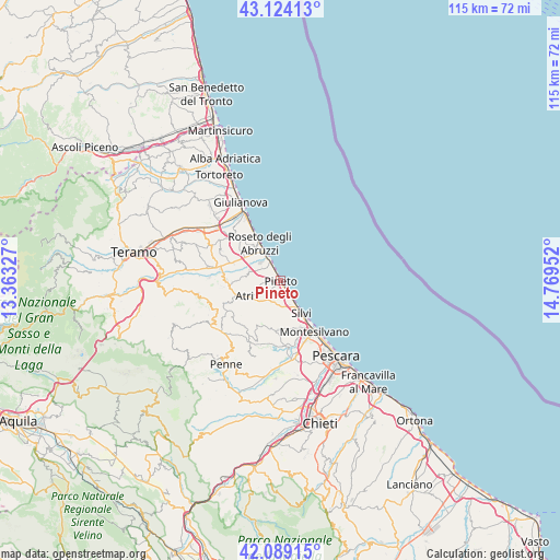
Pineto GPS coordinates[2]
42° 36' 31.644" North, 14° 3' 59.004" East
| Map corner | latitude | longitude |
|---|---|---|
| Upper-left | 43.12413°, | 13.36327° |
| Center: | 42.60879°, | 14.06639° |
| Lower-right: | 42.08915°, | 14.76952° |
| Map W x H: | 115.1×115.1 km | = 71.5×71.5mi |
| max Lat: | 47.04031° ⇑65.7% North |
| Pineto: | 42.60879° |
| min Lat: | ⇓34.3% South 35.50142° |
| min Long | Pineto | max Long |
| 6.69888° | 14.06639° | 18.48682° |
| W 78.7%⇐ | ⇒21.3% E |
Elevation
Elevation of Pineto is 6 m = 20 ft, and this is 300.7 m = 987 ft below average elevation for this country.
| Max E: |
2085 m = 6841 ft | 96.6% |
| Avg. | 306.7 m = 1006 ft | |
| Pineto | 6 m = 20 ft | |
Min E: |
-4 m = -13 ft | 3.4% |
See also: Italy elevation on elevation.city.
Geographical zone
Pineto is located in North temperate zone (between Tropic of Cancer and the Arctic Circle). Distance of this Northern Tropic circle is 2131.7 km =1324.6 mi to South.| Distance of | km | miles | from Pineto |
|---|---|---|---|
| North Pole | 5269.4 | 3274.3 | to North |
| Arctic Circle | 2663.5 | 1655 | to North |
| Tropic Cancer | 2131.7 | 1324.6 | to South |
| Equator | 4737.7 | 2943.9 | to South |


Nearby cities:
15 places around Pineto: (largest is in red/bold)
• Atri
7.3 km =4.5 mi,  240°
240°
• Borgo Santa Maria Immacolata
1.7 km =1.1 mi,  280°
280°
• Casoli
7.2 km =4.5 mi, 277°
• Montepagano
9.8 km =6.1 mi,  320°
320°
• Mutignano
3.5 km =2.2 mi,  228°
228°
• Pagliare
10.2 km =6.3 mi,  292°
292°
• Pianacce
6.1 km =3.8 mi,  163°
163°
• Roseto degli Abruzzi
8.2 km =5.1 mi,  328°
328°
• San Giovanni
8.3 km =5.2 mi,  307°
307°
• Santa Lucia
9.4 km =5.8 mi,  296°
296°
• Santa Maria a Valle
2.1 km =1.3 mi,  148°
148°
• Scerne
4.9 km =3 mi, 331°
• Silvi
7.8 km =4.8 mi, 147°
• Silvi Paese
5.3 km =3.3 mi, 160°
• Zona P.E.E.P.
0.8 km =0.5 mi,  251°
251°
Sources, notices
• [Note1] Compared only with cities in Italy existing in our database
• [Src1] Map data: © OpenStreetMap contributors (CC-BY-SA)
• [Src2] Other city data from geonames.org with taken over terms of usage.
• [Src3] Geographical zone / Annual Mean Temperature by Robert A. Rohde @ Wikipedia
