Savona geodata
Savona (Liguria) is a seat of a second-order administrative division; located in Italy in Europe/Rome (GMT+2) time zone. With population of 58,283 people, there are 91 cities with bigger population in this country. Compared to other cities in Italy, 51.8% of cities are located further ↑North; 88.2% of cities are located further →East and 91.5% of cities have higher elevation than Savona. Note1


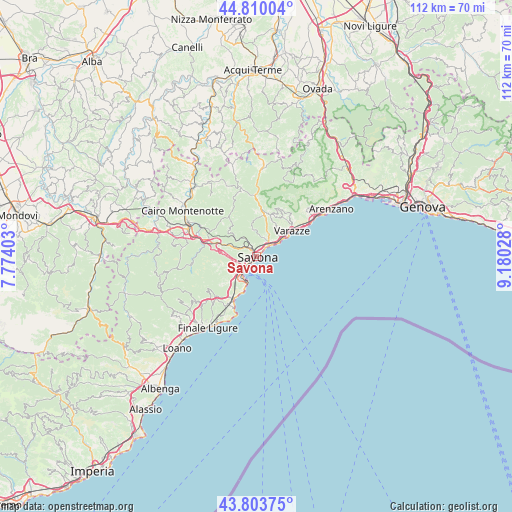
Savona GPS coordinates[2]
44° 18' 32.58" North, 8° 28' 37.74" East
| Map corner | latitude | longitude |
|---|---|---|
| Upper-left | 44.81004°, | 7.77403° |
| Center: | 44.30905°, | 8.47715° |
| Lower-right: | 43.80375°, | 9.18028° |
| Map W x H: | 111.9×111.9 km | = 69.5×69.5mi |
| max Lat: | 47.04031° ⇑51.8% North |
| Savona: | 44.30905° |
| min Lat: | ⇓48.2% South 35.50142° |
| min Long | Savona | max Long |
| 6.69888° | 8.47715° | 18.48682° |
| W 11.8%⇐ | ⇒88.2% E |
Elevation
Elevation of Savona is 15 m = 49 ft, and this is 291.7 m = 957 ft below average elevation for this country.
| Max E: |
2085 m = 6841 ft | 91.5% |
| Avg. | 306.7 m = 1006 ft | |
| Savona | 15 m = 49 ft | |
Min E: |
-4 m = -13 ft | 8.5% |
See also: Savona elevation on elevation.city.
Geographical zone
Savona is located in North temperate zone (between Tropic of Cancer and the Arctic Circle). Distance of this Northern Tropic circle is 2320.8 km =1442.1 mi to South.| Distance of | km | miles | from Savona |
|---|---|---|---|
| North Pole | 5080.4 | 3156.8 | to North |
| Arctic Circle | 2474.5 | 1537.6 | to North |
| Tropic Cancer | 2320.8 | 1442.1 | to South |
| Equator | 4926.7 | 3061.3 | to South |


Nearby cities:
15 places around Savona: (largest is in red/bold)
• Albisola Marina
3.5 km =2.2 mi,  46°
46°
• Albisola Superiore
4.2 km =2.6 mi,  38°
38°
• Bergeggi
7.2 km =4.5 mi,  201°
201°
• Celle Ligure
6.8 km =4.2 mi, 54°
• Ellera
6.2 km =3.9 mi,  351°
351°
• Pero
10.4 km =6.5 mi,  33°
33°
• Quiliano
5.4 km =3.4 mi,  249°
249°
• San Giovanni
9.5 km =5.9 mi,  9°
9°
• San Martino
9.6 km =6 mi,  18°
18°
• Sant'Ermete
8.5 km =5.3 mi,  226°
226°
• Santuario
4.8 km =3 mi,  326°
326°
• Vado Centro
5.7 km =3.5 mi,  218°
218°
• Vado Ligure
5.6 km =3.5 mi, 217°
• Valle di Vado
7.3 km =4.5 mi, 223°
• Valleggia
4.9 km =3 mi, 230°
Sources, notices
• [Note1] Compared only with cities in Italy existing in our database
• [Src1] Map data: © OpenStreetMap contributors (CC-BY-SA)
• [Src2] Other city data from geonames.org with taken over terms of usage.
• [Src3] Geographical zone / Annual Mean Temperature by Robert A. Rohde @ Wikipedia
