Albisola Superiore geodata
Albisola Superiore (Liguria) is a seat of a third-order administrative division; located in Italy in Europe/Rome (GMT+2) time zone. With population of 9,635 people, there are 981 cities with bigger population in this country. Compared to other cities in Italy, 51.4% of cities are located further ↑North; 87.8% of cities are located further →East and 93% of cities have higher elevation than Albisola Superiore. Note1
Administrative division(s):
- Level 1: Liguria
- Level 2: Provincia di Savona
- Level 3: Albisola Superiore


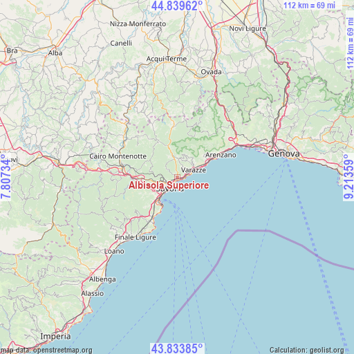
Albisola Superiore GPS coordinates[2]
44° 20' 20.004" North, 8° 30' 37.656" East
| Map corner | latitude | longitude |
|---|---|---|
| Upper-left | 44.83962°, | 7.80734° |
| Center: | 44.33889°, | 8.51046° |
| Lower-right: | 43.83385°, | 9.21359° |
| Map W x H: | 111.8×111.8 km | = 69.5×69.5mi |
| max Lat: | 47.04031° ⇑51.4% North |
| Albisola Superiore: | 44.33889° |
| min Lat: | ⇓48.6% South 35.50142° |
| min Long | Albisola Superi | max Long |
| 6.69888° | 8.51046° | 18.48682° |
| W 12.2%⇐ | ⇒87.8% E |
Elevation
Elevation of Albisola Superiore is 12 m = 39 ft, and this is 294.7 m = 967 ft below average elevation for this country.
| Max E: |
2085 m = 6841 ft | 93% |
| Avg. | 306.7 m = 1006 ft | |
| Albisola Superiore | 12 m = 39 ft | |
Min E: |
-4 m = -13 ft | 7% |
See also: Italy elevation on elevation.city.
Geographical zone
Albisola Superiore is located in North temperate zone (between Tropic of Cancer and the Arctic Circle). Distance of this Northern Tropic circle is 2324.1 km =1444.1 mi to South.| Distance of | km | miles | from Albisola Superiore |
|---|---|---|---|
| North Pole | 5077 | 3154.7 | to North |
| Arctic Circle | 2471.2 | 1535.5 | to North |
| Tropic Cancer | 2324.1 | 1444.1 | to South |
| Equator | 4930 | 3063.4 | to South |


Nearby cities:
15 places around Albisola Superiore: (largest is in red/bold)
• Albisola Marina
0.9 km =0.6 mi,  184°
184°
• Celle Ligure
3 km =1.9 mi,  76°
76°
• Ellera
4.6 km =2.9 mi,  308°
308°
• Osteria dei Cacciatori-Stella
10.6 km =6.6 mi,  342°
342°
• Pero
6.2 km =3.9 mi,  29°
29°
• Quiliano
9.3 km =5.8 mi,  235°
235°
• San Giovanni
6.2 km =3.9 mi,  350°
350°
• San Martino
5.8 km =3.6 mi,  3°
3°
• Santuario
5.3 km =3.3 mi,  277°
277°
• Savona
4.2 km =2.6 mi,  218°
218°
• Sciarborasca
10.9 km =6.8 mi,  50°
50°
• Vado Centro
10 km =6.2 mi, 218°
• Vado Ligure
9.9 km =6.2 mi, 218°
• Valleggia
9.1 km =5.7 mi, 224°
• Varazze
7.4 km =4.6 mi,  67°
67°
Sources, notices
• [Note1] Compared only with cities in Italy existing in our database
• [Src1] Map data: © OpenStreetMap contributors (CC-BY-SA)
• [Src2] Other city data from geonames.org with taken over terms of usage.
• [Src3] Geographical zone / Annual Mean Temperature by Robert A. Rohde @ Wikipedia
