Pero geodata
Pero (Liguria) is a populated place; located in Italy in Europe/Rome (GMT+2) time zone. With population of 679 people, there are 8435 cities with bigger population in this country. Compared to other cities in Italy, 50.7% of cities are located further ↑North; 87.4% of cities are located further →East and 67.1% of cities have higher elevation than Pero. Note1


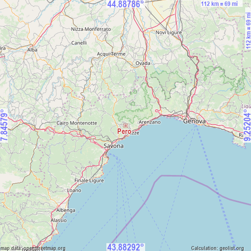
Pero GPS coordinates[2]
44° 23' 15.18" North, 8° 32' 56.076" East
| Map corner | latitude | longitude |
|---|---|---|
| Upper-left | 44.88786°, | 7.84579° |
| Center: | 44.38755°, | 8.54891° |
| Lower-right: | 43.88292°, | 9.25204° |
| Map W x H: | 111.7×111.7 km | = 69.4×69.4mi |
| max Lat: | 47.04031° ⇑50.7% North |
| Pero: | 44.38755° |
| min Lat: | ⇓49.3% South 35.50142° |
| min Long | Pero | max Long |
| 6.69888° | 8.54891° | 18.48682° |
| W 12.6%⇐ | ⇒87.4% E |
Elevation
Elevation of Pero is 115 m = 377 ft, and this is 191.7 m = 629 ft below average elevation for this country.
| Max E: |
2085 m = 6841 ft | 67.1% |
| Avg. | 306.7 m = 1006 ft | |
| Pero | 115 m = 377 ft | |
Min E: |
-4 m = -13 ft | 32.9% |
See also: Italy elevation on elevation.city.
Geographical zone
Pero is located in North temperate zone (between Tropic of Cancer and the Arctic Circle). Distance of this Northern Tropic circle is 2329.5 km =1447.5 mi to South.| Distance of | km | miles | from Pero |
|---|---|---|---|
| North Pole | 5071.6 | 3151.3 | to North |
| Arctic Circle | 2465.7 | 1532.1 | to North |
| Tropic Cancer | 2329.5 | 1447.5 | to South |
| Equator | 4935.4 | 3066.7 | to South |


Nearby cities:
15 places around Pero: (largest is in red/bold)
• Albisola Marina
7 km =4.3 mi,  206°
206°
• Albisola Superiore
6.2 km =3.9 mi, 209°
• Arenzano
10.8 km =6.7 mi,  79°
79°
• Celle Ligure
4.7 km =2.9 mi,  181°
181°
• Cogoleto
7.8 km =4.8 mi,  88°
88°
• Ellera
7.1 km =4.4 mi,  248°
248°
• Lerca
8.2 km =5.1 mi, 77°
• Osteria dei Cacciatori-Stella
7.8 km =4.8 mi,  307°
307°
• Pontinvrea
10.8 km =6.7 mi,  304°
304°
• San Giovanni
4.2 km =2.6 mi,  279°
279°
• San Martino
2.7 km =1.7 mi, 277°
• Santuario
9.6 km =6 mi,  240°
240°
• Savona
10.4 km =6.5 mi, 213°
• Sciarborasca
5.5 km =3.4 mi,  73°
73°
• Varazze
4.6 km =2.9 mi,  124°
124°
Sources, notices
• [Note1] Compared only with cities in Italy existing in our database
• [Src1] Map data: © OpenStreetMap contributors (CC-BY-SA)
• [Src2] Other city data from geonames.org with taken over terms of usage.
• [Src3] Geographical zone / Annual Mean Temperature by Robert A. Rohde @ Wikipedia
