Sassocorvaro geodata
Sassocorvaro (The Marches) is a seat of a third-order administrative division; located in Italy in Europe/Rome (GMT+2) time zone. With population of 954 people, there are 6845 cities with bigger population in this country. Compared to other cities in Italy, 57.2% of cities are located further ↑North; 62.3% of cities are located further ←West and 64.9% of cities have lower elevation than Sassocorvaro. Note1
Administrative division(s):
- Level 1: The Marches
- Level 2: Provincia di Pesaro e Urbino
- Level 3: Sassocorvaro Auditore


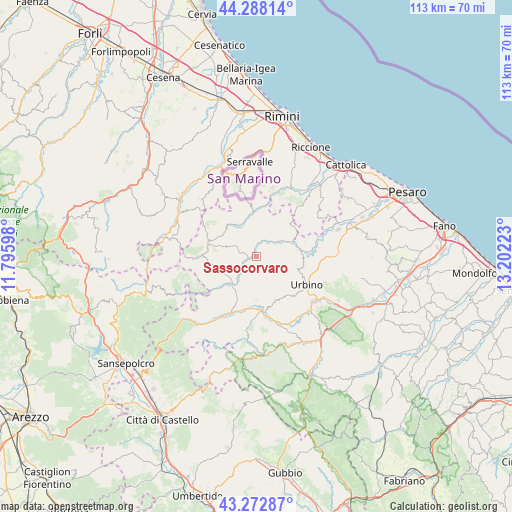
Sassocorvaro GPS coordinates[2]
43° 46' 57.576" North, 12° 29' 56.76" East
| Map corner | latitude | longitude |
|---|---|---|
| Upper-left | 44.28814°, | 11.79598° |
| Center: | 43.78266°, | 12.4991° |
| Lower-right: | 43.27287°, | 13.20223° |
| Map W x H: | 112.9×112.9 km | = 70.2×70.2mi |
| max Lat: | 47.04031° ⇑57.2% North |
| Sassocorvaro: | 43.78266° |
| min Lat: | ⇓42.8% South 35.50142° |
| min Long | Sassocorvaro | max Long |
| 6.69888° | 12.4991° | 18.48682° |
| W 62.3%⇐ | ⇒37.7% E |
Elevation
Elevation of Sassocorvaro is 342 m = 1122 ft, and this is 35.3 m = 116 ft above average elevation for this country.
| Max E: |
2085 m = 6841 ft | 35.1% |
| Sassocorvaro | 342 m 1122 ft | |
| Avg. | 306.7 m = 1006 ft | |
Min E: |
-4 m = -13 ft | 64.9% |
See also: Italy elevation on elevation.city.
Geographical zone
Sassocorvaro is located in North temperate zone (between Tropic of Cancer and the Arctic Circle). Distance of this Northern Tropic circle is 2262.3 km =1405.7 mi to South.| Distance of | km | miles | from Sassocorvaro |
|---|---|---|---|
| North Pole | 5138.9 | 3193.2 | to North |
| Arctic Circle | 2533 | 1573.9 | to North |
| Tropic Cancer | 2262.3 | 1405.7 | to South |
| Equator | 4868.2 | 3025 | to South |


Nearby cities:
15 places around Sassocorvaro: (largest is in red/bold)
• Auditore
7.2 km =4.5 mi,  53°
53°
• Ca' Gallo
9.9 km =6.2 mi,  78°
78°
• Casinina
7.7 km =4.8 mi,  60°
60°
• Frontino
10 km =6.2 mi,  258°
258°
• Gadana
10.6 km =6.6 mi,  110°
110°
• Lunano
7.2 km =4.5 mi,  218°
218°
• Macerata Feltria
5.1 km =3.2 mi,  296°
296°
• Mercatale
1.1 km =0.7 mi,  270°
270°
• Mercatino Conca
9.7 km =6 mi,  356°
356°
• Mercato Vecchio
10.1 km =6.3 mi,  283°
283°
• Monte Cerignone
9.3 km =5.8 mi,  313°
313°
• Monte Grimano Terme
9.7 km =6 mi,  346°
346°
• Peglio
9.6 km =6 mi,  180°
180°
• Piandimeleto
9.8 km =6.1 mi,  227°
227°
• Tavoleto
10.2 km =6.3 mi, 48°
Sources, notices
• [Note1] Compared only with cities in Italy existing in our database
• [Src1] Map data: © OpenStreetMap contributors (CC-BY-SA)
• [Src2] Other city data from geonames.org with taken over terms of usage.
• [Src3] Geographical zone / Annual Mean Temperature by Robert A. Rohde @ Wikipedia
