Tavoleto geodata
Tavoleto (The Marches) is a seat of a third-order administrative division; located in Italy in Europe/Rome (GMT+2) time zone. With population of 707 people, there are 8250 cities with bigger population in this country. Compared to other cities in Italy, 56.4% of cities are located further ↑North; 63.5% of cities are located further ←West and 72.2% of cities have lower elevation than Tavoleto. Note1
Administrative division(s):
- Level 1: The Marches
- Level 2: Provincia di Pesaro e Urbino
- Level 3: Tavoleto


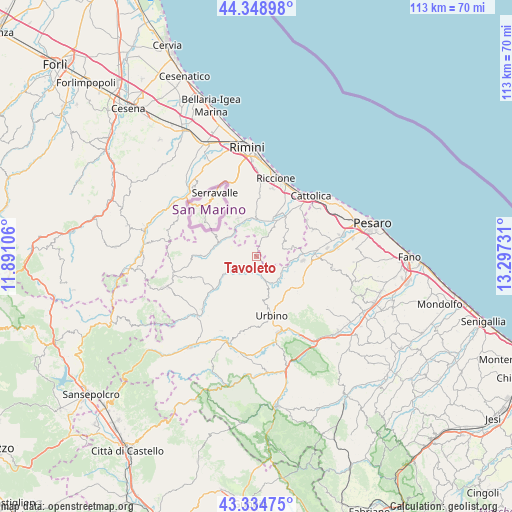
Tavoleto GPS coordinates[2]
43° 50' 38.472" North, 12° 35' 39.048" East
| Map corner | latitude | longitude |
|---|---|---|
| Upper-left | 44.34898°, | 11.89106° |
| Center: | 43.84402°, | 12.59418° |
| Lower-right: | 43.33475°, | 13.29731° |
| Map W x H: | 112.8×112.8 km | = 70.1×70.1mi |
| max Lat: | 47.04031° ⇑56.4% North |
| Tavoleto: | 43.84402° |
| min Lat: | ⇓43.6% South 35.50142° |
| min Long | Tavoleto | max Long |
| 6.69888° | 12.59418° | 18.48682° |
| W 63.5%⇐ | ⇒36.5% E |
Elevation
Elevation of Tavoleto is 417 m = 1368 ft, and this is 110.3 m = 362 ft above average elevation for this country.
| Max E: |
2085 m = 6841 ft | 27.8% |
| Tavoleto | 417 m 1368 ft | |
| Avg. | 306.7 m = 1006 ft | |
Min E: |
-4 m = -13 ft | 72.2% |
See also: Italy elevation on elevation.city.
Geographical zone
Tavoleto is located in North temperate zone (between Tropic of Cancer and the Arctic Circle). Distance of this Northern Tropic circle is 2269.1 km =1410 mi to South.| Distance of | km | miles | from Tavoleto |
|---|---|---|---|
| North Pole | 5132.1 | 3188.9 | to North |
| Arctic Circle | 2526.2 | 1569.7 | to North |
| Tropic Cancer | 2269.1 | 1410 | to South |
| Equator | 4875 | 3029.2 | to South |


Nearby cities:
15 places around Tavoleto: (largest is in red/bold)
• Auditore
3.1 km =1.9 mi,  215°
215°
• Borgo Massano
7.2 km =4.5 mi,  107°
107°
• Ca' Gallo
5.3 km =3.3 mi,  156°
156°
• Casinina
3.2 km =2 mi,  195°
195°
• Falda
7.7 km =4.8 mi,  31°
31°
• Fratte
7.4 km =4.6 mi,  316°
316°
• Gemmano
6.7 km =4.2 mi,  350°
350°
• Mondaino
6.2 km =3.9 mi,  75°
75°
• Montecalvo in Foglia
4.7 km =2.9 mi,  140°
140°
• Montefiore Conca
5.2 km =3.2 mi,  15°
15°
• Montegridolfo
7.8 km =4.8 mi, 78°
• Rio Salso-Case Bernardi
7.8 km =4.8 mi,  97°
97°
• Saludecio
6.4 km =4 mi,  56°
56°
• Sant'Ansovino
6.4 km =4 mi,  47°
47°
• Taverna
8.1 km =5 mi,  338°
338°
Sources, notices
• [Note1] Compared only with cities in Italy existing in our database
• [Src1] Map data: © OpenStreetMap contributors (CC-BY-SA)
• [Src2] Other city data from geonames.org with taken over terms of usage.
• [Src3] Geographical zone / Annual Mean Temperature by Robert A. Rohde @ Wikipedia
