Piandimeleto geodata
Piandimeleto (The Marches) is a seat of a third-order administrative division; located in Italy in Europe/Rome (GMT+1) time zone. With population of 1,580 people, there are 4945 cities with bigger population in this country. Compared to other cities in Italy, 57.9% of cities are located further ↑North; 61.3% of cities are located further ←West and 63.2% of cities have lower elevation than Piandimeleto. Note1
Administrative division(s):
- Level 1: The Marches
- Level 2: Provincia di Pesaro e Urbino
- Level 3: Piandimeleto


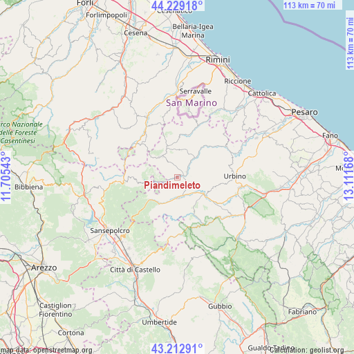
Piandimeleto GPS coordinates[2]
43° 43' 23.52" North, 12° 24' 30.78" East
| Map corner | latitude | longitude |
|---|---|---|
| Upper-left | 44.22918°, | 11.70543° |
| Center: | 43.7232°, | 12.40855° |
| Lower-right: | 43.21291°, | 13.11168° |
| Map W x H: | 113×113 km | = 70.2×70.2mi |
| max Lat: | 47.04031° ⇑57.9% North |
| Piandimeleto: | 43.7232° |
| min Lat: | ⇓42.1% South 35.50142° |
| min Long | Piandimeleto | max Long |
| 6.69888° | 12.40855° | 18.48682° |
| W 61.3%⇐ | ⇒38.7% E |
Elevation
Elevation of Piandimeleto is 325 m = 1066 ft, and this is 18.3 m = 60 ft above average elevation for this country.
| Max E: |
2085 m = 6841 ft | 36.8% |
| Piandimeleto | 325 m 1066 ft | |
| Avg. | 306.7 m = 1006 ft | |
Min E: |
-4 m = -13 ft | 63.2% |
See also: Italy elevation on elevation.city.
Geographical zone
Piandimeleto is located in North temperate zone (between Tropic of Cancer and the Arctic Circle). Distance of this Northern Tropic circle is 2255.6 km =1401.6 mi to South.| Distance of | km | miles | from Piandimeleto |
|---|---|---|---|
| North Pole | 5145.5 | 3197.3 | to North |
| Arctic Circle | 2539.6 | 1578 | to North |
| Tropic Cancer | 2255.6 | 1401.6 | to South |
| Equator | 4861.6 | 3020.9 | to South |


Nearby cities:
15 places around Piandimeleto: (largest is in red/bold)
• Belforte
2.7 km =1.7 mi,  254°
254°
• Borgo Pace
11.8 km =7.3 mi,  232°
232°
• Carpegna
8.7 km =5.4 mi,  317°
317°
• Frontino
5.3 km =3.3 mi,  330°
330°
• Lunano
3 km =1.9 mi,  70°
70°
• Macerata Feltria
9.3 km =5.8 mi,  16°
16°
• Mercatale
9 km =5.6 mi,  42°
42°
• Mercatello sul Metauro
10.3 km =6.4 mi,  214°
214°
• Mercato Vecchio
9.4 km =5.8 mi,  344°
344°
• Monte Cerignone
13 km =8.1 mi,  2°
2°
• Peglio
7.8 km =4.8 mi,  112°
112°
• Sant'Angelo in Vado
6.5 km =4 mi,  173°
173°
• Sassocorvaro
9.8 km =6.1 mi,  47°
47°
• Sestino
9 km =5.6 mi,  260°
260°
• Urbania
10.9 km =6.8 mi,  124°
124°
Sources, notices
• [Note1] Compared only with cities in Italy existing in our database
• [Src1] Map data: © OpenStreetMap contributors (CC-BY-SA)
• [Src2] Other city data from geonames.org with taken over terms of usage.
• [Src3] Geographical zone / Annual Mean Temperature by Robert A. Rohde @ Wikipedia
