Sarteano geodata
Sarteano (Tuscany) is a seat of a third-order administrative division; located in Italy in Europe/Rome (GMT+2) time zone. With population of 4,026 people, there are 2378 cities with bigger population in this country. Compared to other cities in Italy, 63.5% of cities are located further ↑North; 54% of cities are located further ←West and 80.5% of cities have lower elevation than Sarteano. Note1


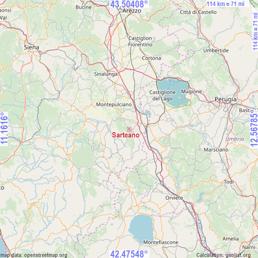
Sarteano GPS coordinates[2]
42° 59' 30.948" North, 11° 51' 52.992" East
| Map corner | latitude | longitude |
|---|---|---|
| Upper-left | 43.50408°, | 11.1616° |
| Center: | 42.99193°, | 11.86472° |
| Lower-right: | 42.47548°, | 12.56785° |
| Map W x H: | 114.4×114.4 km | = 71.1×71.1mi |
| max Lat: | 47.04031° ⇑63.5% North |
| Sarteano: | 42.99193° |
| min Lat: | ⇓36.5% South 35.50142° |
| min Long | Sarteano | max Long |
| 6.69888° | 11.86472° | 18.48682° |
| W 54%⇐ | ⇒46% E |
Elevation
Elevation of Sarteano is 531 m = 1742 ft, and this is 224.3 m = 736 ft above average elevation for this country.
| Max E: |
2085 m = 6841 ft | 19.5% |
| Sarteano | 531 m 1742 ft | |
| Avg. | 306.7 m = 1006 ft | |
Min E: |
-4 m = -13 ft | 80.5% |
See also: Italy elevation on elevation.city.
Geographical zone
Sarteano is located in North temperate zone (between Tropic of Cancer and the Arctic Circle). Distance of this Northern Tropic circle is 2174.3 km =1351 mi to South.| Distance of | km | miles | from Sarteano |
|---|---|---|---|
| North Pole | 5226.8 | 3247.8 | to North |
| Arctic Circle | 2620.9 | 1628.6 | to North |
| Tropic Cancer | 2174.3 | 1351 | to South |
| Equator | 4780.3 | 2970.3 | to South |


Nearby cities:
15 places around Sarteano: (largest is in red/bold)
• Acquaviva
13.8 km =8.6 mi,  359°
359°
• Cetona
4.2 km =2.6 mi,  132°
132°
• Chianciano Terme
7 km =4.3 mi,  322°
322°
• Chiusi
7.2 km =4.5 mi,  69°
69°
• Chiusi Scalo
7.3 km =4.5 mi,  86°
86°
• Città della Pieve
12.1 km =7.5 mi,  107°
107°
• Moiano
12.8 km =8 mi,  78°
78°
• Montepulciano
13.6 km =8.5 mi,  332°
332°
• Piazze
10.3 km =6.4 mi,  155°
155°
• Po' Bandino
8.7 km =5.4 mi, 82°
• Ponticelli
11.2 km =7 mi, 126°
• Radicofani
13.2 km =8.2 mi,  216°
216°
• San Casciano dei Bagni
13.6 km =8.5 mi,  175°
175°
• Sant'Albino
10 km =6.2 mi, 331°
• Tre Berte
11.9 km =7.4 mi,  10°
10°
Sources, notices
• [Note1] Compared only with cities in Italy existing in our database
• [Src1] Map data: © OpenStreetMap contributors (CC-BY-SA)
• [Src2] Other city data from geonames.org with taken over terms of usage.
• [Src3] Geographical zone / Annual Mean Temperature by Robert A. Rohde @ Wikipedia
