San Casciano dei Bagni geodata
San Casciano dei Bagni (Tuscany) is a seat of a third-order administrative division; located in Italy in Europe/Rome (GMT+2) time zone. With population of 530 people, there are 9642 cities with bigger population in this country. Compared to other cities in Italy, 64.2% of cities are located further ↑North; 54.2% of cities are located further ←West and 82.6% of cities have lower elevation than San Casciano dei Bagni. Note1
Administrative division(s):
- Level 1: Tuscany
- Level 2: Provincia di Siena
- Level 3: San Casciano dei Bagni
Current local time in San Casciano dei Bagni:
11:45 PM, WednesdayDifference from your time zone: hours


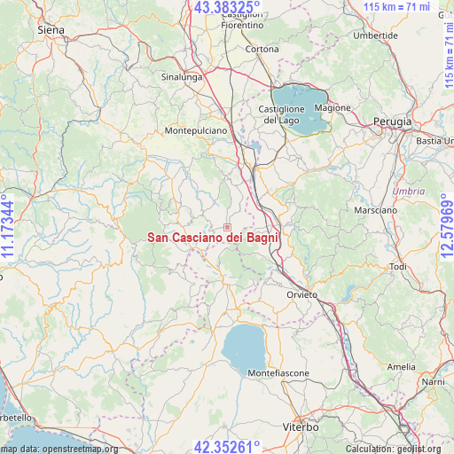
San Casciano dei Bagni GPS coordinates[2]
42° 52' 12.288" North, 11° 52' 35.616" East
| Map corner | latitude | longitude |
|---|---|---|
| Upper-left | 43.38325°, | 11.17344° |
| Center: | 42.87008°, | 11.87656° |
| Lower-right: | 42.35261°, | 12.57969° |
| Map W x H: | 114.6×114.6 km | = 71.2×71.2mi |
| max Lat: | 47.04031° ⇑64.2% North |
| San Casciano dei Bagni: | 42.87008° |
| min Lat: | ⇓35.8% South 35.50142° |
| min Long | San Casciano de | max Long |
| 6.69888° | 11.87656° | 18.48682° |
| W 54.2%⇐ | ⇒45.8% E |
Elevation
Elevation of San Casciano dei Bagni is 565 m = 1854 ft, and this is 258.3 m = 847 ft above average elevation for this country.
| Max E: |
2085 m = 6841 ft | 17.4% |
| San Casciano dei Bagni | 565 m 1854 ft | |
| Avg. | 306.7 m = 1006 ft | |
Min E: |
-4 m = -13 ft | 82.6% |
See also: Italy elevation on elevation.city.
Geographical zone
San Casciano dei Bagni is located in North temperate zone (between Tropic of Cancer and the Arctic Circle). Distance of this Northern Tropic circle is 2160.8 km =1342.7 mi to South.| Distance of | km | miles | from San Casciano dei Bagni |
|---|---|---|---|
| North Pole | 5240.4 | 3256.2 | to North |
| Arctic Circle | 2634.5 | 1637 | to North |
| Tropic Cancer | 2160.8 | 1342.7 | to South |
| Equator | 4766.7 | 2961.9 | to South |


Nearby cities:
15 places around San Casciano dei Bagni: (largest is in red/bold)
• Acquapendente
14.2 km =8.8 mi,  182°
182°
• Allerona
10.3 km =6.4 mi,  129°
129°
• Cetona
10.9 km =6.8 mi,  11°
11°
• Chiusi Scalo
15.4 km =9.6 mi,  24°
24°
• Città della Pieve
14.5 km =9 mi,  46°
46°
• Fabro
11.3 km =7 mi,  88°
88°
• Fabro Scalo
13.8 km =8.6 mi, 87°
• Monteleone d'Orvieto
15.5 km =9.6 mi,  68°
68°
• Piancastagnaio
15.3 km =9.5 mi,  261°
261°
• Piazze
5.3 km =3.3 mi,  37°
37°
• Ponticelli
10.5 km =6.5 mi, 49°
• Proceno
13.1 km =8.1 mi,  197°
197°
• Radicofani
9.3 km =5.8 mi,  288°
288°
• Santa Maria
13.4 km =8.3 mi,  79°
79°
• Sarteano
13.6 km =8.5 mi,  355°
355°
Sources, notices
• [Note1] Compared only with cities in Italy existing in our database
• [Src1] Map data: © OpenStreetMap contributors (CC-BY-SA)
• [Src2] Other city data from geonames.org with taken over terms of usage.
• [Src3] Geographical zone / Annual Mean Temperature by Robert A. Rohde @ Wikipedia
