Montepulciano geodata
Montepulciano (Tuscany) is a seat of a third-order administrative division; located in Italy in Europe/Rome (GMT+2) time zone. With population of 3,446 people, there are 2719 cities with bigger population in this country. Compared to other cities in Italy, 62.6% of cities are located further ↑North; 52.9% of cities are located further ←West and 78% of cities have lower elevation than Montepulciano. Note1


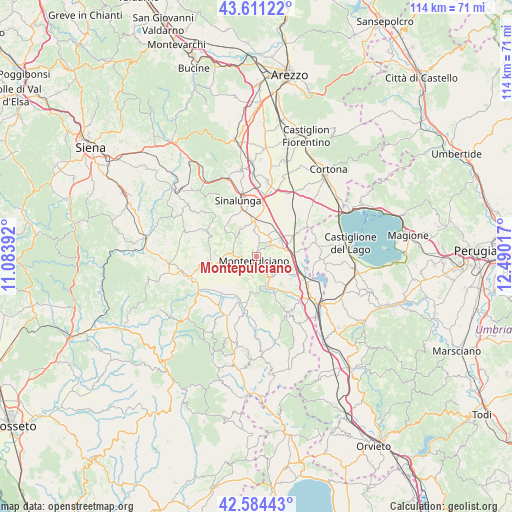
Montepulciano GPS coordinates[2]
43° 5' 59.928" North, 11° 47' 13.344" East
| Map corner | latitude | longitude |
|---|---|---|
| Upper-left | 43.61122°, | 11.08392° |
| Center: | 43.09998°, | 11.78704° |
| Lower-right: | 42.58443°, | 12.49017° |
| Map W x H: | 114.2×114.2 km | = 71×71mi |
| max Lat: | 47.04031° ⇑62.6% North |
| Montepulciano: | 43.09998° |
| min Lat: | ⇓37.4% South 35.50142° |
| min Long | Montepulciano | max Long |
| 6.69888° | 11.78704° | 18.48682° |
| W 52.9%⇐ | ⇒47.1% E |
Elevation
Elevation of Montepulciano is 492 m = 1614 ft, and this is 185.3 m = 608 ft above average elevation for this country.
| Max E: |
2085 m = 6841 ft | 22% |
| Montepulciano | 492 m 1614 ft | |
| Avg. | 306.7 m = 1006 ft | |
Min E: |
-4 m = -13 ft | 78% |
See also: Italy elevation on elevation.city.
Geographical zone
Montepulciano is located in North temperate zone (between Tropic of Cancer and the Arctic Circle). Distance of this Northern Tropic circle is 2186.3 km =1358.5 mi to South.| Distance of | km | miles | from Montepulciano |
|---|---|---|---|
| North Pole | 5214.8 | 3240.3 | to North |
| Arctic Circle | 2608.9 | 1621.1 | to North |
| Tropic Cancer | 2186.3 | 1358.5 | to South |
| Equator | 4792.3 | 2977.8 | to South |


Nearby cities:
15 places around Montepulciano: (largest is in red/bold)
• Acquaviva
6.4 km =4 mi,  74°
74°
• Bettolle
11.9 km =7.4 mi,  6°
6°
• Chianciano Terme
6.8 km =4.2 mi,  162°
162°
• Gracciano
5 km =3.1 mi,  43°
43°
• Guazzino
12.5 km =7.8 mi,  358°
358°
• Montepulciano Stazione
6.8 km =4.2 mi,  54°
54°
• Pienza
9.3 km =5.8 mi,  255°
255°
• Pozzuolo
13.9 km =8.6 mi,  80°
80°
• San Quirico d'Orcia
15.5 km =9.6 mi,  252°
252°
• Sant'Albino
3.6 km =2.2 mi,  153°
153°
• Sarteano
13.6 km =8.5 mi, 152°
• Sinalunga
13.2 km =8.2 mi,  345°
345°
• Torrita di Siena
8.1 km =5 mi, 358°
• Tre Berte
8.4 km =5.2 mi,  91°
91°
• Trequanda
13.7 km =8.5 mi,  315°
315°
Sources, notices
• [Note1] Compared only with cities in Italy existing in our database
• [Src1] Map data: © OpenStreetMap contributors (CC-BY-SA)
• [Src2] Other city data from geonames.org with taken over terms of usage.
• [Src3] Geographical zone / Annual Mean Temperature by Robert A. Rohde @ Wikipedia
