Sarmede geodata
Sarmede (Veneto) is a seat of a third-order administrative division; located in Italy in Europe/Rome (GMT+2) time zone. With population of 1,075 people, there are 6386 cities with bigger population in this country. Compared to other cities in Italy, 91.3% of cities are located further ↓South; 61.1% of cities are located further ←West and 70% of cities have higher elevation than Sarmede. Note1


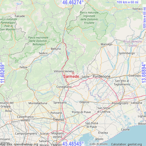
Sarmede GPS coordinates[2]
45° 58' 34.5" North, 12° 23' 8.916" East
| Map corner | latitude | longitude |
|---|---|---|
| Upper-left | 46.46274°, | 11.68269° |
| Center: | 45.97625°, | 12.38581° |
| Lower-right: | 45.48545°, | 13.08894° |
| Map W x H: | 108.7×108.7 km | = 67.5×67.5mi |
| max Lat: | 47.04031° ⇑8.7% North |
| Sarmede: | 45.97625° |
| min Lat: | ⇓91.3% South 35.50142° |
| min Long | Sarmede | max Long |
| 6.69888° | 12.38581° | 18.48682° |
| W 61.1%⇐ | ⇒38.9% E |
Elevation
Elevation of Sarmede is 97 m = 318 ft, and this is 209.7 m = 688 ft below average elevation for this country.
| Max E: |
2085 m = 6841 ft | 70% |
| Avg. | 306.7 m = 1006 ft | |
| Sarmede | 97 m = 318 ft | |
Min E: |
-4 m = -13 ft | 30% |
See also: Italy elevation on elevation.city.
Geographical zone
Sarmede is located in North temperate zone (between Tropic of Cancer and the Arctic Circle). Distance of this North polar circle is 2289.1 km =1422.4 mi to North.| Distance of | km | miles | from Sarmede |
|---|---|---|---|
| North Pole | 4895 | 3041.6 | to North |
| Arctic Circle | 2289.1 | 1422.4 | to North |
| Tropic Cancer | 2506.2 | 1557.3 | to South |
| Equator | 5112.1 | 3176.5 | to South |


Nearby cities:
15 places around Sarmede: (largest is in red/bold)
• Caneva
5.2 km =3.2 mi,  96°
96°
• Cappella Maggiore
2.2 km =1.4 mi,  257°
257°
• Colle Umberto
5.1 km =3.2 mi,  221°
221°
• Cordignano
3.8 km =2.4 mi,  142°
142°
• Fregona
5.1 km =3.2 mi,  314°
314°
• Godega
5.4 km =3.4 mi,  170°
170°
• Mescolino-Minelle
3 km =1.9 mi, 218°
• Montaner
2.5 km =1.6 mi,  347°
347°
• Orsago
6.1 km =3.8 mi,  148°
148°
• Osigo
4.8 km =3 mi,  325°
325°
• San Fior di Sopra
6.3 km =3.9 mi,  197°
197°
• San Martino
4.2 km =2.6 mi,  240°
240°
• Scomigo
6.3 km =3.9 mi,  233°
233°
• Villa di Villa
2.5 km =1.6 mi,  115°
115°
• Vittorio Veneto
6.6 km =4.1 mi,  273°
273°
Sources, notices
• [Note1] Compared only with cities in Italy existing in our database
• [Src1] Map data: © OpenStreetMap contributors (CC-BY-SA)
• [Src2] Other city data from geonames.org with taken over terms of usage.
• [Src3] Geographical zone / Annual Mean Temperature by Robert A. Rohde @ Wikipedia
