San Vito geodata
San Vito (Veneto) is a seat of a third-order administrative division; located in Italy in Europe/Rome (GMT+2) time zone. With population of 1,548 people, there are 5013 cities with bigger population in this country. Compared to other cities in Italy, 98.2% of cities are located further ↓South; 58.7% of cities are located further ←West and 97.3% of cities have lower elevation than San Vito. Note1
Administrative division(s):
- Level 1: Veneto
- Level 2: Provincia di Belluno
- Level 3: San Vito di Cadore


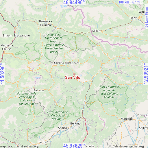
San Vito GPS coordinates[2]
46° 27' 46.008" North, 12° 12' 21.888" East
| Map corner | latitude | longitude |
|---|---|---|
| Upper-left | 46.94496°, | 11.50296° |
| Center: | 46.46278°, | 12.20608° |
| Lower-right: | 45.97629°, | 12.90921° |
| Map W x H: | 107.7×107.7 km | = 66.9×66.9mi |
| max Lat: | 47.04031° ⇑1.8% North |
| San Vito: | 46.46278° |
| min Lat: | ⇓98.2% South 35.50142° |
| min Long | San Vito | max Long |
| 6.69888° | 12.20608° | 18.48682° |
| W 58.7%⇐ | ⇒41.3% E |
Elevation
Elevation of San Vito is 1022 m = 3353 ft, and this is 715.3 m = 2347 ft above average elevation for this country.
| Max E: |
2085 m = 6841 ft | 2.7% |
| San Vito | 1022 m 3353 ft | |
| Avg. | 306.7 m = 1006 ft | |
Min E: |
-4 m = -13 ft | 97.3% |
See also: Italy elevation on elevation.city.
Geographical zone
San Vito is located in North temperate zone (between Tropic of Cancer and the Arctic Circle). Distance of this North polar circle is 2235 km =1388.8 mi to North.| Distance of | km | miles | from San Vito |
|---|---|---|---|
| North Pole | 4840.9 | 3008 | to North |
| Arctic Circle | 2235 | 1388.8 | to North |
| Tropic Cancer | 2560.3 | 1590.9 | to South |
| Equator | 5166.2 | 3210.1 | to South |


Nearby cities:
15 places around San Vito: (largest is in red/bold)
• Borca
3.4 km =2.1 mi,  158°
158°
• Bortolot
8.9 km =5.5 mi,  196°
196°
• Calalzo di Cadore
13.6 km =8.5 mi,  97°
97°
• Cibiana
10.3 km =6.4 mi,  143°
143°
• Cortina d'Ampezzo
9.7 km =6 mi,  328°
328°
• Forno di Zoldo
12.7 km =7.9 mi,  189°
189°
• Fusine
11.5 km =7.1 mi,  212°
212°
• Pieve di Cadore
12.8 km =8 mi,  109°
109°
• Pozzale
12.5 km =7.8 mi, 103°
• Selva di Cadore
11.5 km =7.1 mi,  263°
263°
• Valle di Cadore
11 km =6.8 mi,  116°
116°
• Venas
9.2 km =5.7 mi,  129°
129°
• Vodo
5.7 km =3.5 mi,  148°
148°
• Zoldo Alto
11.4 km =7.1 mi, 211°
• Zoppè di Cadore
8.9 km =5.5 mi, 196°
In other languages:
- In France: San Vito di Cadore
- In German: San Vito di Cadore
- In Italian: San Vito di Cadore
Sources, notices
• [Note1] Compared only with cities in Italy existing in our database
• [Src1] Map data: © OpenStreetMap contributors (CC-BY-SA)
• [Src2] Other city data from geonames.org with taken over terms of usage.
• [Src3] Geographical zone / Annual Mean Temperature by Robert A. Rohde @ Wikipedia
