Santu Lussurgiu geodata
Santu Lussurgiu (Sardinia) is a seat of a third-order administrative division; located in Italy in Europe/Rome (GMT+2) time zone. With population of 2,394 people, there are 3641 cities with bigger population in this country. Compared to other cities in Italy, 86.8% of cities are located further ↑North; 86.1% of cities are located further →East and 80.8% of cities have lower elevation than Santu Lussurgiu. Note1
Administrative division(s):
- Level 1: Sardinia
- Level 2: Provincia di Oristano
- Level 3: Santu Lussurgiu


Santu Lussurgiu GPS coordinates[2]
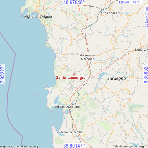
40° 8' 27.96" North, 8° 39' 19.404" East
| Map corner | latitude | longitude |
|---|---|---|
| Upper-left | 40.67648°, | 7.95227° |
| Center: | 40.1411°, | 8.65539° |
| Lower-right: | 39.60147°, | 9.35852° |
| Map W x H: | 119.5×119.5 km | = 74.3×74.3mi |
| max Lat: | 47.04031° ⇑86.8% North |
| Santu Lussurgiu: | 40.1411° |
| min Lat: | ⇓13.2% South 35.50142° |
| min Long | Santu Lussurgiu | max Long |
| 6.69888° | 8.65539° | 18.48682° |
| W 13.9%⇐ | ⇒86.1% E |
Elevation
Elevation of Santu Lussurgiu is 536 m = 1759 ft, and this is 229.3 m = 752 ft above average elevation for this country.
| Max E: |
2085 m = 6841 ft | 19.2% |
| Santu Lussurgiu | 536 m 1759 ft | |
| Avg. | 306.7 m = 1006 ft | |
Min E: |
-4 m = -13 ft | 80.8% |
See also: Italy elevation on elevation.city.
Geographical zone
Santu Lussurgiu is located in North temperate zone (between Tropic of Cancer and the Arctic Circle). Distance of this Northern Tropic circle is 1857.4 km =1154.1 mi to South.| Distance of | km | miles | from Santu Lussurgiu |
|---|---|---|---|
| North Pole | 5543.8 | 3444.8 | to North |
| Arctic Circle | 2937.9 | 1825.5 | to North |
| Tropic Cancer | 1857.4 | 1154.1 | to South |
| Equator | 4463.3 | 2773.4 | to South |


Nearby cities:
15 places around Santu Lussurgiu: (largest is in red/bold)
• Abbasanta
13.9 km =8.6 mi,  95°
95°
• Bauladu
13.5 km =8.4 mi,  174°
174°
• Bonarcado
4.8 km =3 mi,  180°
180°
• Borore
15.1 km =9.4 mi,  56°
56°
• Cuglieri
9.1 km =5.7 mi,  305°
305°
• Milis
10.2 km =6.3 mi,  188°
188°
• Narbolia
12.4 km =7.7 mi,  213°
213°
• Norbello
15 km =9.3 mi,  92°
92°
• Paulilatino
11.2 km =7 mi,  124°
124°
• Sagama
14.9 km =9.3 mi,  333°
333°
• San Vero Milis
15 km =9.3 mi,  198°
198°
• Scano di Montiferro
10.1 km =6.3 mi,  324°
324°
• Seneghe
7.5 km =4.7 mi, 208°
• Sennariolo
11.6 km =7.2 mi, 313°
• Tramatza
15.4 km =9.6 mi, 181°
Sources, notices
• [Note1] Compared only with cities in Italy existing in our database
• [Src1] Map data: © OpenStreetMap contributors (CC-BY-SA)
• [Src2] Other city data from geonames.org with taken over terms of usage.
• [Src3] Geographical zone / Annual Mean Temperature by Robert A. Rohde @ Wikipedia
