Seneghe geodata
Seneghe (Sardinia) is a seat of a third-order administrative division; located in Italy in Europe/Rome (GMT+2) time zone. With population of 1,840 people, there are 4424 cities with bigger population in this country. Compared to other cities in Italy, 87.3% of cities are located further ↑North; 86.5% of cities are located further →East and 61.5% of cities have lower elevation than Seneghe. Note1


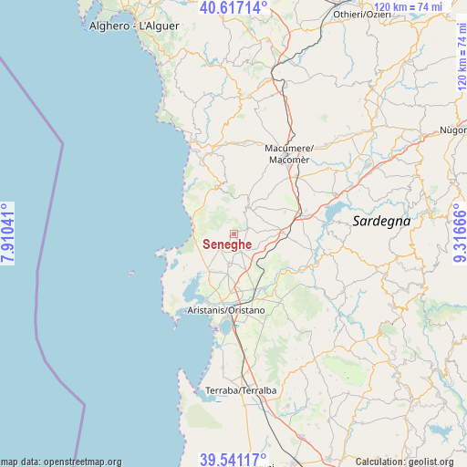
Seneghe GPS coordinates[2]
40° 4' 52.608" North, 8° 36' 48.708" East
| Map corner | latitude | longitude |
|---|---|---|
| Upper-left | 40.61714°, | 7.91041° |
| Center: | 40.08128°, | 8.61353° |
| Lower-right: | 39.54117°, | 9.31666° |
| Map W x H: | 119.6×119.6 km | = 74.3×74.3mi |
| max Lat: | 47.04031° ⇑87.3% North |
| Seneghe: | 40.08128° |
| min Lat: | ⇓12.7% South 35.50142° |
| min Long | Seneghe | max Long |
| 6.69888° | 8.61353° | 18.48682° |
| W 13.5%⇐ | ⇒86.5% E |
Elevation
Elevation of Seneghe is 311 m = 1020 ft, and this is 4.3 m = 14 ft above average elevation for this country.
| Max E: |
2085 m = 6841 ft | 38.5% |
| Seneghe | 311 m 1020 ft | |
| Avg. | 306.7 m = 1006 ft | |
Min E: |
-4 m = -13 ft | 61.5% |
See also: Italy elevation on elevation.city.
Geographical zone
Seneghe is located in North temperate zone (between Tropic of Cancer and the Arctic Circle). Distance of this Northern Tropic circle is 1850.7 km =1150 mi to South.| Distance of | km | miles | from Seneghe |
|---|---|---|---|
| North Pole | 5550.4 | 3448.9 | to North |
| Arctic Circle | 2944.6 | 1829.7 | to North |
| Tropic Cancer | 1850.7 | 1150 | to South |
| Equator | 4456.6 | 2769.2 | to South |


Nearby cities:
15 places around Seneghe: (largest is in red/bold)
• Baratili San Pietro
11.1 km =6.9 mi,  206°
206°
• Bauladu
8.4 km =5.2 mi,  143°
143°
• Bonarcado
4 km =2.5 mi,  61°
61°
• Cuglieri
12.5 km =7.8 mi,  341°
341°
• Milis
4 km =2.5 mi,  149°
149°
• Narbolia
4.9 km =3 mi,  221°
221°
• Nurachi
13.4 km =8.3 mi, 207°
• Paulilatino
12.8 km =8 mi,  88°
88°
• Riola Sardo
11.5 km =7.1 mi, 212°
• San Vero Milis
7.6 km =4.7 mi,  189°
189°
• Santu Lussurgiu
7.5 km =4.7 mi,  28°
28°
• Siamaggiore
14.7 km =9.1 mi,  173°
173°
• Solarussa
15 km =9.3 mi,  159°
159°
• Tramatza
9.2 km =5.7 mi, 160°
• Zeddiani
10.4 km =6.5 mi, 188°
Sources, notices
• [Note1] Compared only with cities in Italy existing in our database
• [Src1] Map data: © OpenStreetMap contributors (CC-BY-SA)
• [Src2] Other city data from geonames.org with taken over terms of usage.
• [Src3] Geographical zone / Annual Mean Temperature by Robert A. Rohde @ Wikipedia
