Santa Teresa Gallura geodata
Santa Teresa Gallura (Sardinia) is a seat of a third-order administrative division; located in Italy in Europe/Rome (GMT+2) time zone. With population of 3,283 people, there are 2849 cities with bigger population in this country. Compared to other cities in Italy, 76.6% of cities are located further ↑North; 78.2% of cities are located further →East and 87.4% of cities have higher elevation than Santa Teresa Gallura. Note1
Administrative division(s):
- Level 1: Sardinia
- Level 2: Provincia di Sassari
- Level 3: Santa Teresa Gallura
Current local time in Santa Teresa Gallura:
11:34 PM, WednesdayDifference from your time zone: hours


Santa Teresa Gallura GPS coordinates[2]
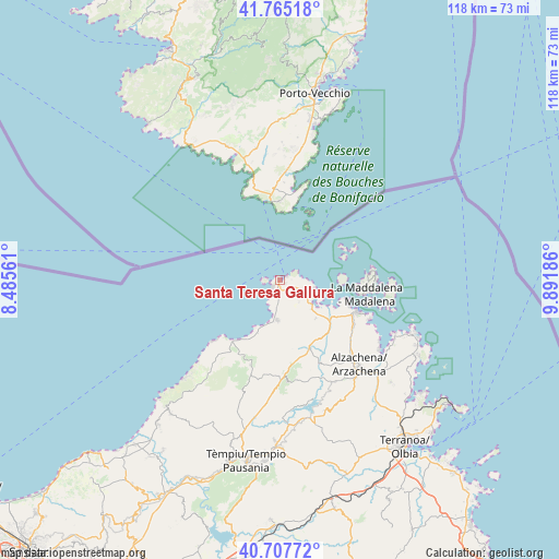
41° 14' 18.924" North, 9° 11' 19.428" East
| Map corner | latitude | longitude |
|---|---|---|
| Upper-left | 41.76518°, | 8.48561° |
| Center: | 41.23859°, | 9.18873° |
| Lower-right: | 40.70772°, | 9.89186° |
| Map W x H: | 117.6×117.6 km | = 73.1×73.1mi |
| max Lat: | 47.04031° ⇑76.6% North |
| Santa Teresa Gallura: | 41.23859° |
| min Lat: | ⇓23.4% South 35.50142° |
| min Long | Santa Teresa Ga | max Long |
| 6.69888° | 9.18873° | 18.48682° |
| W 21.8%⇐ | ⇒78.2% E |
Elevation
Elevation of Santa Teresa Gallura is 24 m = 79 ft, and this is 282.7 m = 927 ft below average elevation for this country.
| Max E: |
2085 m = 6841 ft | 87.4% |
| Avg. | 306.7 m = 1006 ft | |
| Santa Teresa Gallura | 24 m = 79 ft | |
Min E: |
-4 m = -13 ft | 12.6% |
See also: Italy elevation on elevation.city.
Geographical zone
Santa Teresa Gallura is located in North temperate zone (between Tropic of Cancer and the Arctic Circle). Distance of this Northern Tropic circle is 1979.4 km =1229.9 mi to South.| Distance of | km | miles | from Santa Teresa Gallura |
|---|---|---|---|
| North Pole | 5421.8 | 3368.9 | to North |
| Arctic Circle | 2815.9 | 1749.7 | to North |
| Tropic Cancer | 1979.4 | 1229.9 | to South |
| Equator | 4585.3 | 2849.2 | to South |


Nearby cities:
15 places around Santa Teresa Gallura: (largest is in red/bold)
• Aggius
35.8 km =22.2 mi,  196°
196°
• Aglientu
18.8 km =11.7 mi, 199°
• Arzachena
24.7 km =15.3 mi,  136°
136°
• Calangianus
35.4 km =22 mi,  179°
179°
• Cannigione
25 km =15.5 mi,  123°
123°
• La Maddalena
18.6 km =11.6 mi,  98°
98°
• Luogosanto
21.4 km =13.3 mi, 176°
• Luras
33.6 km =20.9 mi, 181°
• Palau
17.4 km =10.8 mi,  112°
112°
• Porto Cervo
30.8 km =19.1 mi, 110°
• San Pantaleo
31.7 km =19.7 mi,  132°
132°
• Sant'Antonio di Gallura
29.1 km =18.1 mi,  161°
161°
• Tempio Pausania
38.2 km =23.7 mi,  190°
190°
• Trinità d'Agultu
36.3 km =22.6 mi,  219°
219°
• Trinità d'Agultu e Vignola
36.4 km =22.6 mi, 218°
Sources, notices
• [Note1] Compared only with cities in Italy existing in our database
• [Src1] Map data: © OpenStreetMap contributors (CC-BY-SA)
• [Src2] Other city data from geonames.org with taken over terms of usage.
• [Src3] Geographical zone / Annual Mean Temperature by Robert A. Rohde @ Wikipedia
