Arzachena geodata
Arzachena (Sardinia) is a seat of a third-order administrative division; located in Italy in Europe/Rome (GMT+2) time zone. With population of 6,199 people, there are 1581 cities with bigger population in this country. Compared to other cities in Italy, 77.7% of cities are located further ↑North; 74.7% of cities are located further →East and 79% of cities have higher elevation than Arzachena. Note1


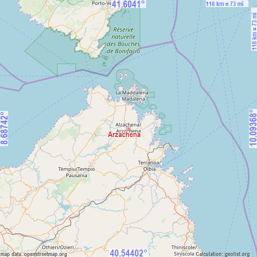
Arzachena GPS coordinates[2]
41° 4' 34.32" North, 9° 23' 25.98" East
| Map corner | latitude | longitude |
|---|---|---|
| Upper-left | 41.6041°, | 8.68742° |
| Center: | 41.0762°, | 9.39055° |
| Lower-right: | 40.54402°, | 10.09368° |
| Map W x H: | 117.9×117.9 km | = 73.3×73.3mi |
| max Lat: | 47.04031° ⇑77.7% North |
| Arzachena: | 41.0762° |
| min Lat: | ⇓22.3% South 35.50142° |
| min Long | Arzachena | max Long |
| 6.69888° | 9.39055° | 18.48682° |
| W 25.3%⇐ | ⇒74.7% E |
Elevation
Elevation of Arzachena is 54 m = 177 ft, and this is 252.7 m = 829 ft below average elevation for this country.
| Max E: |
2085 m = 6841 ft | 79% |
| Avg. | 306.7 m = 1006 ft | |
| Arzachena | 54 m = 177 ft | |
Min E: |
-4 m = -13 ft | 21% |
See also: Italy elevation on elevation.city.
Geographical zone
Arzachena is located in North temperate zone (between Tropic of Cancer and the Arctic Circle). Distance of this Northern Tropic circle is 1961.3 km =1218.7 mi to South.| Distance of | km | miles | from Arzachena |
|---|---|---|---|
| North Pole | 5439.8 | 3380.1 | to North |
| Arctic Circle | 2833.9 | 1760.9 | to North |
| Tropic Cancer | 1961.3 | 1218.7 | to South |
| Equator | 4567.2 | 2837.9 | to South |


Nearby cities:
15 places around Arzachena: (largest is in red/bold)
• Aglientu
23.3 km =14.5 mi,  270°
270°
• Calangianus
24 km =14.9 mi,  223°
223°
• Cannigione
5.8 km =3.6 mi,  42°
42°
• Golfo Aranci
20.3 km =12.6 mi,  112°
112°
• Golfo Aranci
22.8 km =14.2 mi,  116°
116°
• La Maddalena
15.4 km =9.6 mi,  5°
5°
• Luogosanto
15.9 km =9.9 mi,  258°
258°
• Luras
23.9 km =14.9 mi,  229°
229°
• Olbia
19.2 km =11.9 mi,  152°
152°
• Palau
11.5 km =7.1 mi,  356°
356°
• Pittulongu
20.7 km =12.9 mi,  133°
133°
• Porto Cervo
13.9 km =8.6 mi,  58°
58°
• San Pantaleo
7.3 km =4.5 mi, 117°
• Sant'Antonio di Gallura
12 km =7.5 mi, 218°
• Telti
22.5 km =14 mi,  187°
187°
Sources, notices
• [Note1] Compared only with cities in Italy existing in our database
• [Src1] Map data: © OpenStreetMap contributors (CC-BY-SA)
• [Src2] Other city data from geonames.org with taken over terms of usage.
• [Src3] Geographical zone / Annual Mean Temperature by Robert A. Rohde @ Wikipedia
