Cannigione geodata
Cannigione (Sardinia) is a populated place; located in Italy in Europe/Rome (GMT+2) time zone. With population of 782 people, there are 7740 cities with bigger population in this country. Compared to other cities in Italy, 77.4% of cities are located further ↑North; 74.1% of cities are located further →East and 92.6% of cities have higher elevation than Cannigione. Note1


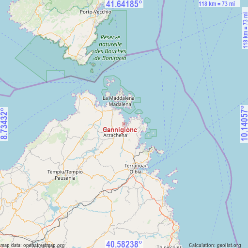
Cannigione GPS coordinates[2]
41° 6' 51.3" North, 9° 26' 14.784" East
| Map corner | latitude | longitude |
|---|---|---|
| Upper-left | 41.64185°, | 8.73432° |
| Center: | 41.11425°, | 9.43744° |
| Lower-right: | 40.58238°, | 10.14057° |
| Map W x H: | 117.8×117.8 km | = 73.2×73.2mi |
| max Lat: | 47.04031° ⇑77.4% North |
| Cannigione: | 41.11425° |
| min Lat: | ⇓22.6% South 35.50142° |
| min Long | Cannigione | max Long |
| 6.69888° | 9.43744° | 18.48682° |
| W 25.9%⇐ | ⇒74.1% E |
Elevation
Elevation of Cannigione is 13 m = 43 ft, and this is 293.7 m = 964 ft below average elevation for this country.
| Max E: |
2085 m = 6841 ft | 92.6% |
| Avg. | 306.7 m = 1006 ft | |
| Cannigione | 13 m = 43 ft | |
Min E: |
-4 m = -13 ft | 7.4% |
See also: Italy elevation on elevation.city.
Geographical zone
Cannigione is located in North temperate zone (between Tropic of Cancer and the Arctic Circle). Distance of this Northern Tropic circle is 1965.6 km =1221.4 mi to South.| Distance of | km | miles | from Cannigione |
|---|---|---|---|
| North Pole | 5435.6 | 3377.5 | to North |
| Arctic Circle | 2829.7 | 1758.3 | to North |
| Tropic Cancer | 1965.6 | 1221.4 | to South |
| Equator | 4571.5 | 2840.6 | to South |


Nearby cities:
15 places around Cannigione: (largest is in red/bold)
• Aglientu
27.5 km =17.1 mi,  261°
261°
• Arzachena
5.8 km =3.6 mi,  222°
222°
• Golfo Aranci
19.1 km =11.9 mi,  128°
128°
• Golfo Aranci
21.9 km =13.6 mi, 131°
• La Maddalena
11.4 km =7.1 mi,  347°
347°
• Luogosanto
20.8 km =12.9 mi,  248°
248°
• Murta Maria
27.9 km =17.3 mi,  153°
153°
• Olbia
21.8 km =13.5 mi,  166°
166°
• Palau
8.6 km =5.3 mi,  327°
327°
• Pittulongu
21.6 km =13.4 mi, 148°
• Porto Cervo
8.5 km =5.3 mi,  69°
69°
• San Pantaleo
8 km =5 mi,  161°
161°
• Sant'Antonio di Gallura
17.8 km =11.1 mi, 219°
• Santa Teresa Gallura
25 km =15.5 mi,  303°
303°
• Telti
27.4 km =17 mi,  194°
194°
Sources, notices
• [Note1] Compared only with cities in Italy existing in our database
• [Src1] Map data: © OpenStreetMap contributors (CC-BY-SA)
• [Src2] Other city data from geonames.org with taken over terms of usage.
• [Src3] Geographical zone / Annual Mean Temperature by Robert A. Rohde @ Wikipedia
