La Maddalena geodata
La Maddalena (Sardinia) is a seat of a third-order administrative division; located in Italy in Europe/Rome (GMT+2) time zone. With population of 10,297 people, there are 920 cities with bigger population in this country. Compared to other cities in Italy, 76.8% of cities are located further ↑North; 74.3% of cities are located further →East and 97.2% of cities have higher elevation than La Maddalena. Note1


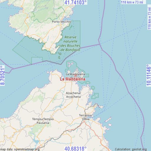
La Maddalena GPS coordinates[2]
41° 12' 51.264" North, 9° 24' 29.988" East
| Map corner | latitude | longitude |
|---|---|---|
| Upper-left | 41.74103°, | 8.70521° |
| Center: | 41.21424°, | 9.40833° |
| Lower-right: | 40.68318°, | 10.11146° |
| Map W x H: | 117.6×117.6 km | = 73.1×73.1mi |
| max Lat: | 47.04031° ⇑76.8% North |
| La Maddalena: | 41.21424° |
| min Lat: | ⇓23.2% South 35.50142° |
| min Long | La Maddalena | max Long |
| 6.69888° | 9.40833° | 18.48682° |
| W 25.7%⇐ | ⇒74.3% E |
Elevation
Elevation of La Maddalena is 5 m = 16 ft, and this is 301.7 m = 990 ft below average elevation for this country.
| Max E: |
2085 m = 6841 ft | 97.2% |
| Avg. | 306.7 m = 1006 ft | |
| La Maddalena | 5 m = 16 ft | |
Min E: |
-4 m = -13 ft | 2.8% |
See also: Italy elevation on elevation.city.
Geographical zone
La Maddalena is located in North temperate zone (between Tropic of Cancer and the Arctic Circle). Distance of this Northern Tropic circle is 1976.7 km =1228.3 mi to South.| Distance of | km | miles | from La Maddalena |
|---|---|---|---|
| North Pole | 5424.5 | 3370.6 | to North |
| Arctic Circle | 2818.6 | 1751.4 | to North |
| Tropic Cancer | 1976.7 | 1228.3 | to South |
| Equator | 4582.6 | 2847.5 | to South |


Nearby cities:
15 places around La Maddalena: (largest is in red/bold)
• Aglientu
29 km =18 mi,  238°
238°
• Arzachena
15.4 km =9.6 mi,  185°
185°
• Calangianus
37.3 km =23.2 mi,  208°
208°
• Cannigione
11.4 km =7.1 mi,  167°
167°
• Golfo Aranci
28.8 km =17.9 mi,  143°
143°
• Golfo Aranci
31.9 km =19.8 mi, 143°
• Luogosanto
25.2 km =15.7 mi,  222°
222°
• Luras
36.6 km =22.7 mi, 212°
• Olbia
33.2 km =20.6 mi, 166°
• Palau
4.5 km =2.8 mi, 209°
• Pittulongu
32.5 km =20.2 mi,  155°
155°
• Porto Cervo
13.2 km =8.2 mi,  128°
128°
• San Pantaleo
19.4 km =12.1 mi, 165°
• Sant'Antonio di Gallura
26.3 km =16.3 mi,  199°
199°
• Santa Teresa Gallura
18.6 km =11.6 mi,  278°
278°
Sources, notices
• [Note1] Compared only with cities in Italy existing in our database
• [Src1] Map data: © OpenStreetMap contributors (CC-BY-SA)
• [Src2] Other city data from geonames.org with taken over terms of usage.
• [Src3] Geographical zone / Annual Mean Temperature by Robert A. Rohde @ Wikipedia
