Santa Severa geodata
Santa Severa (Latium) is a populated place; located in Italy in Europe/Rome (GMT+2) time zone. With population of 970 people, there are 6778 cities with bigger population in this country. Compared to other cities in Italy, 70.1% of cities are located further ↑North; 55.2% of cities are located further ←West and 95.9% of cities have higher elevation than Santa Severa. Note1
Administrative division(s):
- Level 1: Latium
- Level 2: Città metropolitana di Roma Capitale
- Level 3: Santa Marinella


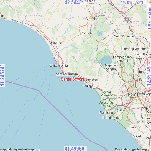
Santa Severa GPS coordinates[2]
42° 1' 26.868" North, 11° 56' 54.096" East
| Map corner | latitude | longitude |
|---|---|---|
| Upper-left | 42.54431°, | 11.24524° |
| Center: | 42.02413°, | 11.94836° |
| Lower-right: | 41.49966°, | 12.65149° |
| Map W x H: | 116.2×116.2 km | = 72.2×72.2mi |
| max Lat: | 47.04031° ⇑70.1% North |
| Santa Severa: | 42.02413° |
| min Lat: | ⇓29.9% South 35.50142° |
| min Long | Santa Severa | max Long |
| 6.69888° | 11.94836° | 18.48682° |
| W 55.2%⇐ | ⇒44.8% E |
Elevation
Elevation of Santa Severa is 7 m = 23 ft, and this is 299.7 m = 983 ft below average elevation for this country.
| Max E: |
2085 m = 6841 ft | 95.9% |
| Avg. | 306.7 m = 1006 ft | |
| Santa Severa | 7 m = 23 ft | |
Min E: |
-4 m = -13 ft | 4.1% |
See also: Italy elevation on elevation.city.
Geographical zone
Santa Severa is located in North temperate zone (between Tropic of Cancer and the Arctic Circle). Distance of this Northern Tropic circle is 2066.7 km =1284.2 mi to South.| Distance of | km | miles | from Santa Severa |
|---|---|---|---|
| North Pole | 5334.4 | 3314.6 | to North |
| Arctic Circle | 2728.5 | 1695.4 | to North |
| Tropic Cancer | 2066.7 | 1284.2 | to South |
| Equator | 4672.6 | 2903.4 | to South |


Nearby cities:
15 places around Santa Severa: (largest is in red/bold)
• Allumiere
15.3 km =9.5 mi,  346°
346°
• Aurelia
18.5 km =11.5 mi,  313°
313°
• Bracciano
20 km =12.4 mi,  64°
64°
• Canale Monterano
17.8 km =11.1 mi,  45°
45°
• Cerveteri
12.3 km =7.6 mi,  107°
107°
• Civitavecchia
14.7 km =9.1 mi,  301°
301°
• Ladispoli
13.3 km =8.3 mi,  127°
127°
• Manziana
18.8 km =11.7 mi, 51°
• Marina San Nicola
17.6 km =10.9 mi, 126°
• Marina di Cerveteri
9.9 km =6.2 mi,  119°
119°
• Prato del Mare
10.2 km =6.3 mi,  285°
285°
• Santa Marinella
7.9 km =4.9 mi,  278°
278°
• Santa Severa Nord
2 km =1.2 mi,  93°
93°
• Tolfa
14.1 km =8.8 mi, 354°
• Valcanneto
19.1 km =11.9 mi, 115°
Sources, notices
• [Note1] Compared only with cities in Italy existing in our database
• [Src1] Map data: © OpenStreetMap contributors (CC-BY-SA)
• [Src2] Other city data from geonames.org with taken over terms of usage.
• [Src3] Geographical zone / Annual Mean Temperature by Robert A. Rohde @ Wikipedia
