Ladispoli geodata
Ladispoli (Latium) is a seat of a third-order administrative division; located in Italy in Europe/Rome (GMT+2) time zone. With population of 34,204 people, there are 225 cities with bigger population in this country. Compared to other cities in Italy, 70.8% of cities are located further ↑North; 56.9% of cities are located further ←West and 95.3% of cities have higher elevation than Ladispoli. Note1
Administrative division(s):
- Level 1: Latium
- Level 2: Città metropolitana di Roma Capitale
- Level 3: Ladispoli


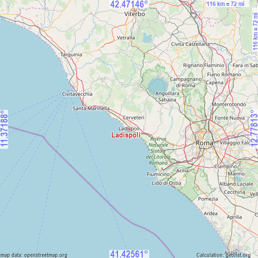
Ladispoli GPS coordinates[2]
41° 57' 2.448" North, 12° 4' 30" East
| Map corner | latitude | longitude |
|---|---|---|
| Upper-left | 42.47146°, | 11.37188° |
| Center: | 41.95068°, | 12.075° |
| Lower-right: | 41.42561°, | 12.77813° |
| Map W x H: | 116.3×116.3 km | = 72.3×72.3mi |
| max Lat: | 47.04031° ⇑70.8% North |
| Ladispoli: | 41.95068° |
| min Lat: | ⇓29.2% South 35.50142° |
| min Long | Ladispoli | max Long |
| 6.69888° | 12.075° | 18.48682° |
| W 56.9%⇐ | ⇒43.1% E |
Elevation
Elevation of Ladispoli is 8 m = 26 ft, and this is 298.7 m = 980 ft below average elevation for this country.
| Max E: |
2085 m = 6841 ft | 95.3% |
| Avg. | 306.7 m = 1006 ft | |
| Ladispoli | 8 m = 26 ft | |
Min E: |
-4 m = -13 ft | 4.7% |
See also: Italy elevation on elevation.city.
Geographical zone
Ladispoli is located in North temperate zone (between Tropic of Cancer and the Arctic Circle). Distance of this Northern Tropic circle is 2058.6 km =1279.2 mi to South.| Distance of | km | miles | from Ladispoli |
|---|---|---|---|
| North Pole | 5342.6 | 3319.7 | to North |
| Arctic Circle | 2736.7 | 1700.5 | to North |
| Tropic Cancer | 2058.6 | 1279.2 | to South |
| Equator | 4664.5 | 2898.4 | to South |


Nearby cities:
15 places around Ladispoli: (largest is in red/bold)
• Ara Nova
13.8 km =8.6 mi,  98°
98°
• Centro Tre Denari
11 km =6.8 mi,  110°
110°
• Cerveteri
4.6 km =2.9 mi,  16°
16°
• Fregene
15 km =9.3 mi,  137°
137°
• Maccarese
14.5 km =9 mi,  124°
124°
• Maccarese-Stazione
15.8 km =9.8 mi, 121°
• Marina San Nicola
4.3 km =2.7 mi, 120°
• Marina di Cerveteri
3.7 km =2.3 mi,  330°
330°
• Palidoro
8.9 km =5.5 mi, 105°
• Passoscuro
8.7 km =5.4 mi,  128°
128°
• Ponton dell'Elce
15.5 km =9.6 mi,  58°
58°
• Santa Severa
13.3 km =8.3 mi,  307°
307°
• Santa Severa Nord
11.7 km =7.3 mi, 313°
• Tragliatella Campitello
16.2 km =10.1 mi, 64°
• Valcanneto
6.8 km =4.2 mi,  89°
89°
Sources, notices
• [Note1] Compared only with cities in Italy existing in our database
• [Src1] Map data: © OpenStreetMap contributors (CC-BY-SA)
• [Src2] Other city data from geonames.org with taken over terms of usage.
• [Src3] Geographical zone / Annual Mean Temperature by Robert A. Rohde @ Wikipedia
