Sant'Agostino geodata
Sant'Agostino (Emilia-Romagna) is a seat of a third-order administrative division; located in Italy in Europe/Rome (GMT+2) time zone. With population of 2,867 people, there are 3150 cities with bigger population in this country. Compared to other cities in Italy, 56% of cities are located further ↓South; 52.1% of cities are located further →East and 88.7% of cities have higher elevation than Sant'Agostino. Note1
Administrative division(s):
- Level 1: Emilia-Romagna
- Level 2: Provincia di Ferrara
- Level 3: Terre del Reno


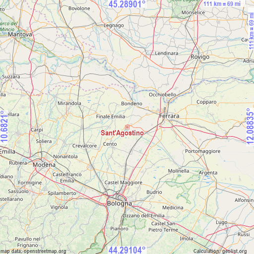
Sant'Agostino GPS coordinates[2]
44° 47' 31.848" North, 11° 23' 6.792" East
| Map corner | latitude | longitude |
|---|---|---|
| Upper-left | 45.28901°, | 10.6821° |
| Center: | 44.79218°, | 11.38522° |
| Lower-right: | 44.29104°, | 12.08835° |
| Map W x H: | 111×111 km | = 69×69mi |
| max Lat: | 47.04031° ⇑44% North |
| Sant'Agostino: | 44.79218° |
| min Lat: | ⇓56% South 35.50142° |
| min Long | Sant'Agostino | max Long |
| 6.69888° | 11.38522° | 18.48682° |
| W 47.9%⇐ | ⇒52.1% E |
Elevation
Elevation of Sant'Agostino is 21 m = 69 ft, and this is 285.7 m = 937 ft below average elevation for this country.
| Max E: |
2085 m = 6841 ft | 88.7% |
| Avg. | 306.7 m = 1006 ft | |
| Sant'Agostino | 21 m = 69 ft | |
Min E: |
-4 m = -13 ft | 11.3% |
See also: Italy elevation on elevation.city.
Geographical zone
Sant'Agostino is located in North temperate zone (between Tropic of Cancer and the Arctic Circle). Distance of this Northern Tropic circle is 2374.5 km =1475.4 mi to South.| Distance of | km | miles | from Sant'Agostino |
|---|---|---|---|
| North Pole | 5026.6 | 3123.4 | to North |
| Arctic Circle | 2420.8 | 1504.2 | to North |
| Tropic Cancer | 2374.5 | 1475.4 | to South |
| Equator | 4980.4 | 3094.7 | to South |


Nearby cities:
15 places around Sant'Agostino: (largest is in red/bold)
• Corpo Reno
7.3 km =4.5 mi,  236°
236°
• Dodici Morelli
7.4 km =4.6 mi,  270°
270°
• Dosso
4.5 km =2.8 mi,  233°
233°
• Finale Emilia
8.6 km =5.3 mi,  302°
302°
• Galliera
4.8 km =3 mi,  171°
171°
• Maccaretolo
9 km =5.6 mi,  156°
156°
• Mirabello
6.6 km =4.1 mi,  58°
58°
• Poggio Renatico
8.5 km =5.3 mi,  110°
110°
• Renazzo
8.4 km =5.2 mi,  249°
249°
• Reno Centese
5.9 km =3.7 mi,  312°
312°
• San Carlo
2.3 km =1.4 mi, 56°
• San Pietro in Casale
10.3 km =6.4 mi, 171°
• San Venanzio
6.6 km =4.1 mi,  141°
141°
• San Vincenzo
7.2 km =4.5 mi,  145°
145°
• Vigarano Mainarda
10.1 km =6.3 mi, 57°
Sources, notices
• [Note1] Compared only with cities in Italy existing in our database
• [Src1] Map data: © OpenStreetMap contributors (CC-BY-SA)
• [Src2] Other city data from geonames.org with taken over terms of usage.
• [Src3] Geographical zone / Annual Mean Temperature by Robert A. Rohde @ Wikipedia
