Maccaretolo geodata
Maccaretolo (Emilia-Romagna) is a populated place; located in Italy in Europe/Rome (GMT+2) time zone. With population of 593 people, there are 9070 cities with bigger population in this country. Compared to other cities in Italy, 54.5% of cities are located further ↓South; 51.5% of cities are located further →East and 92.1% of cities have higher elevation than Maccaretolo. Note1


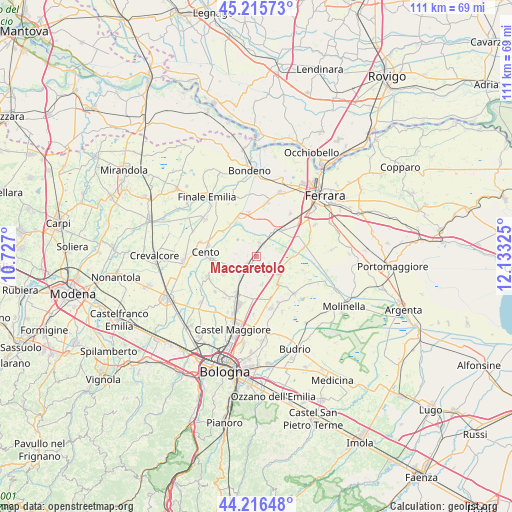
Maccaretolo GPS coordinates[2]
44° 43' 5.736" North, 11° 25' 48.432" East
| Map corner | latitude | longitude |
|---|---|---|
| Upper-left | 45.21573°, | 10.727° |
| Center: | 44.71826°, | 11.43012° |
| Lower-right: | 44.21648°, | 12.13325° |
| Map W x H: | 111.1×111.1 km | = 69×69mi |
| max Lat: | 47.04031° ⇑45.5% North |
| Maccaretolo: | 44.71826° |
| min Lat: | ⇓54.5% South 35.50142° |
| min Long | Maccaretolo | max Long |
| 6.69888° | 11.43012° | 18.48682° |
| W 48.5%⇐ | ⇒51.5% E |
Elevation
Elevation of Maccaretolo is 14 m = 46 ft, and this is 292.7 m = 960 ft below average elevation for this country.
| Max E: |
2085 m = 6841 ft | 92.1% |
| Avg. | 306.7 m = 1006 ft | |
| Maccaretolo | 14 m = 46 ft | |
Min E: |
-4 m = -13 ft | 7.9% |
See also: Italy elevation on elevation.city.
Geographical zone
Maccaretolo is located in North temperate zone (between Tropic of Cancer and the Arctic Circle). Distance of this Northern Tropic circle is 2366.3 km =1470.4 mi to South.| Distance of | km | miles | from Maccaretolo |
|---|---|---|---|
| North Pole | 5034.9 | 3128.5 | to North |
| Arctic Circle | 2429 | 1509.3 | to North |
| Tropic Cancer | 2366.3 | 1470.4 | to South |
| Equator | 4972.2 | 3089.6 | to South |


Nearby cities:
15 places around Maccaretolo: (largest is in red/bold)
• Altedo
7.1 km =4.4 mi,  138°
138°
• Bentivoglio
9.1 km =5.7 mi,  186°
186°
• Dosso
9.1 km =5.7 mi,  307°
307°
• Galliera
4.5 km =2.8 mi,  320°
320°
• Malalbergo
8.1 km =5 mi,  89°
89°
• Pegola
6.3 km =3.9 mi,  118°
118°
• Pieve di Cento
9.6 km =6 mi,  266°
266°
• Poggio Renatico
6.9 km =4.3 mi,  40°
40°
• San Carlo
9.6 km =6 mi,  350°
350°
• San Giorgio di Piano
9 km =5.6 mi,  209°
209°
• San Pietro in Casale
2.8 km =1.7 mi,  225°
225°
• San Venanzio
3 km =1.9 mi,  10°
10°
• San Vincenzo
2.3 km =1.4 mi, 12°
• Sant'Agostino
9 km =5.6 mi,  336°
336°
• Venezzano
8.6 km =5.3 mi,  243°
243°
Sources, notices
• [Note1] Compared only with cities in Italy existing in our database
• [Src1] Map data: © OpenStreetMap contributors (CC-BY-SA)
• [Src2] Other city data from geonames.org with taken over terms of usage.
• [Src3] Geographical zone / Annual Mean Temperature by Robert A. Rohde @ Wikipedia
