Sant'Agapito geodata
Sant'Agapito (Molise) is a seat of a third-order administrative division; located in Italy in Europe/Rome (GMT+2) time zone. With population of 523 people, there are 9703 cities with bigger population in this country. Compared to other cities in Italy, 74.4% of cities are located further ↑North; 80% of cities are located further ←West and 82.7% of cities have lower elevation than Sant'Agapito. Note1


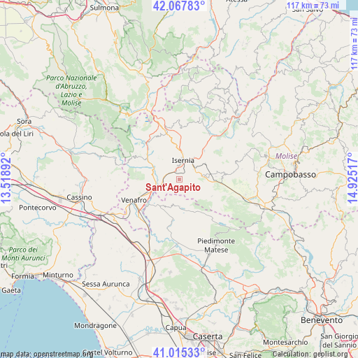
Sant'Agapito GPS coordinates[2]
41° 32' 37.392" North, 14° 13' 19.344" East
| Map corner | latitude | longitude |
|---|---|---|
| Upper-left | 42.06783°, | 13.51892° |
| Center: | 41.54372°, | 14.22204° |
| Lower-right: | 41.01533°, | 14.92517° |
| Map W x H: | 117×117 km | = 72.7×72.7mi |
| max Lat: | 47.04031° ⇑74.4% North |
| Sant'Agapito: | 41.54372° |
| min Lat: | ⇓25.6% South 35.50142° |
| min Long | Sant'Agapito | max Long |
| 6.69888° | 14.22204° | 18.48682° |
| W 80%⇐ | ⇒20% E |
Elevation
Elevation of Sant'Agapito is 567 m = 1860 ft, and this is 260.3 m = 854 ft above average elevation for this country.
| Max E: |
2085 m = 6841 ft | 17.3% |
| Sant'Agapito | 567 m 1860 ft | |
| Avg. | 306.7 m = 1006 ft | |
Min E: |
-4 m = -13 ft | 82.7% |
See also: Italy elevation on elevation.city.
Geographical zone
Sant'Agapito is located in North temperate zone (between Tropic of Cancer and the Arctic Circle). Distance of this Northern Tropic circle is 2013.3 km =1251 mi to South.| Distance of | km | miles | from Sant'Agapito |
|---|---|---|---|
| North Pole | 5387.8 | 3347.8 | to North |
| Arctic Circle | 2781.9 | 1728.6 | to North |
| Tropic Cancer | 2013.3 | 1251 | to South |
| Equator | 4619.2 | 2870.2 | to South |


Nearby cities:
15 places around Sant'Agapito: (largest is in red/bold)
• Castelpizzuto
6.3 km =3.9 mi,  113°
113°
• Castelromano
8.6 km =5.3 mi,  346°
346°
• Fornelli
9.8 km =6.1 mi,  315°
315°
• Gallo
8.8 km =5.5 mi,  178°
178°
• Gallo Matese
8.8 km =5.5 mi, 178°
• Indiprete
9.8 km =6.1 mi,  88°
88°
• Isernia
5.9 km =3.7 mi,  9°
9°
• Longano
3.2 km =2 mi,  139°
139°
• Macchia d'Isernia
4.7 km =2.9 mi,  293°
293°
• Montaquila
9.4 km =5.8 mi,  284°
284°
• Monteroduni
4.5 km =2.8 mi,  238°
238°
• Pesche
8.2 km =5.1 mi,  33°
33°
• Pettoranello del Molise
5.7 km =3.5 mi,  54°
54°
• Sant'Eusanio
6.2 km =3.9 mi,  255°
255°
• Taverna Ravindola
8.3 km =5.2 mi,  253°
253°
Sources, notices
• [Note1] Compared only with cities in Italy existing in our database
• [Src1] Map data: © OpenStreetMap contributors (CC-BY-SA)
• [Src2] Other city data from geonames.org with taken over terms of usage.
• [Src3] Geographical zone / Annual Mean Temperature by Robert A. Rohde @ Wikipedia
