Castelromano geodata
Castelromano (Molise) is a populated place; located in Italy in Europe/Rome (GMT+2) time zone. With population of 515 people, there are 9776 cities with bigger population in this country. Compared to other cities in Italy, 73.8% of cities are located further ↑North; 79.8% of cities are located further ←West and 86.5% of cities have lower elevation than Castelromano. Note1


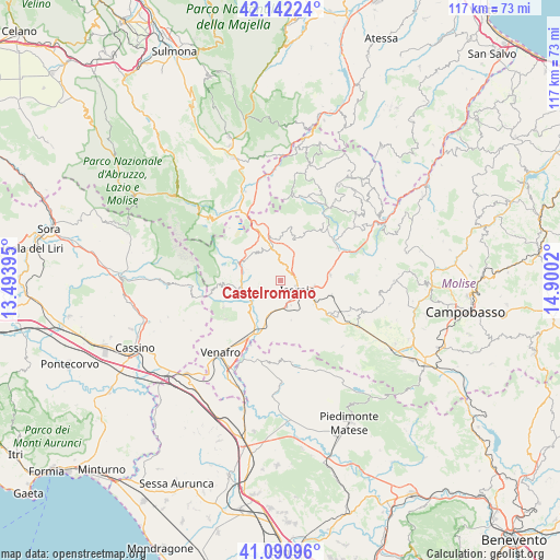
Castelromano GPS coordinates[2]
41° 37' 7.464" North, 14° 11' 49.452" East
| Map corner | latitude | longitude |
|---|---|---|
| Upper-left | 42.14224°, | 13.49395° |
| Center: | 41.61874°, | 14.19707° |
| Lower-right: | 41.09096°, | 14.9002° |
| Map W x H: | 116.9×116.9 km | = 72.6×72.6mi |
| max Lat: | 47.04031° ⇑73.8% North |
| Castelromano: | 41.61874° |
| min Lat: | ⇓26.2% South 35.50142° |
| min Long | Castelromano | max Long |
| 6.69888° | 14.19707° | 18.48682° |
| W 79.8%⇐ | ⇒20.2% E |
Elevation
Elevation of Castelromano is 642 m = 2106 ft, and this is 335.3 m = 1100 ft above average elevation for this country.
| Max E: |
2085 m = 6841 ft | 13.5% |
| Castelromano | 642 m 2106 ft | |
| Avg. | 306.7 m = 1006 ft | |
Min E: |
-4 m = -13 ft | 86.5% |
See also: Italy elevation on elevation.city.
Geographical zone
Castelromano is located in North temperate zone (between Tropic of Cancer and the Arctic Circle). Distance of this Northern Tropic circle is 2021.7 km =1256.2 mi to South.| Distance of | km | miles | from Castelromano |
|---|---|---|---|
| North Pole | 5379.5 | 3342.7 | to North |
| Arctic Circle | 2773.6 | 1723.4 | to North |
| Tropic Cancer | 2021.7 | 1256.2 | to South |
| Equator | 4627.6 | 2875.5 | to South |


Nearby cities:
15 places around Castelromano: (largest is in red/bold)
• Acquaviva d'Isernia
7.1 km =4.4 mi,  324°
324°
• Cerro al Volturno
8.7 km =5.4 mi,  296°
296°
• Colli a Volturno
8.1 km =5 mi,  255°
255°
• Forlì del Sannio
8.7 km =5.4 mi,  350°
350°
• Fornelli
4.9 km =3 mi,  254°
254°
• Isernia
4 km =2.5 mi,  129°
129°
• Macchia d'Isernia
6.8 km =4.2 mi,  199°
199°
• Miranda
5 km =3.1 mi,  55°
55°
• Montaquila
9.2 km =5.7 mi,  229°
229°
• Pesche
6.7 km =4.2 mi,  102°
102°
• Pettoranello del Molise
8.4 km =5.2 mi, 126°
• Roccasicura
9.1 km =5.7 mi,  17°
17°
• Rocchetta Nuova
9.3 km =5.8 mi,  273°
273°
• Rocchetta a Volturno
9 km =5.6 mi,  275°
275°
• Sant'Agapito
8.6 km =5.3 mi,  166°
166°
Sources, notices
• [Note1] Compared only with cities in Italy existing in our database
• [Src1] Map data: © OpenStreetMap contributors (CC-BY-SA)
• [Src2] Other city data from geonames.org with taken over terms of usage.
• [Src3] Geographical zone / Annual Mean Temperature by Robert A. Rohde @ Wikipedia
