Pesche geodata
Pesche (Molise) is a seat of a third-order administrative division; located in Italy in Europe/Rome (GMT+2) time zone. With population of 1,363 people, there are 5462 cities with bigger population in this country. Compared to other cities in Italy, 73.9% of cities are located further ↑North; 80.6% of cities are located further ←West and 82.7% of cities have lower elevation than Pesche. Note1


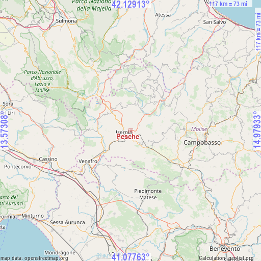
Pesche GPS coordinates[2]
41° 36' 19.872" North, 14° 16' 34.32" East
| Map corner | latitude | longitude |
|---|---|---|
| Upper-left | 42.12913°, | 13.57308° |
| Center: | 41.60552°, | 14.2762° |
| Lower-right: | 41.07763°, | 14.97933° |
| Map W x H: | 116.9×116.9 km | = 72.6×72.6mi |
| max Lat: | 47.04031° ⇑73.9% North |
| Pesche: | 41.60552° |
| min Lat: | ⇓26.1% South 35.50142° |
| min Long | Pesche | max Long |
| 6.69888° | 14.2762° | 18.48682° |
| W 80.6%⇐ | ⇒19.4% E |
Elevation
Elevation of Pesche is 566 m = 1857 ft, and this is 259.3 m = 851 ft above average elevation for this country.
| Max E: |
2085 m = 6841 ft | 17.3% |
| Pesche | 566 m 1857 ft | |
| Avg. | 306.7 m = 1006 ft | |
Min E: |
-4 m = -13 ft | 82.7% |
See also: Italy elevation on elevation.city.
Geographical zone
Pesche is located in North temperate zone (between Tropic of Cancer and the Arctic Circle). Distance of this Northern Tropic circle is 2020.2 km =1255.3 mi to South.| Distance of | km | miles | from Pesche |
|---|---|---|---|
| North Pole | 5381 | 3343.6 | to North |
| Arctic Circle | 2775.1 | 1724.4 | to North |
| Tropic Cancer | 2020.2 | 1255.3 | to South |
| Equator | 4626.1 | 2874.5 | to South |


Nearby cities:
15 places around Pesche: (largest is in red/bold)
• Carpinone
4.4 km =2.7 mi,  113°
113°
• Castelpetroso
7.7 km =4.8 mi,  130°
130°
• Castelpizzuto
9.5 km =5.9 mi,  171°
171°
• Castelromano
6.7 km =4.2 mi,  282°
282°
• Indiprete
8.5 km =5.3 mi,  141°
141°
• Isernia
3.7 km =2.3 mi,  253°
253°
• Longano
9.6 km =6 mi,  194°
194°
• Macchia d'Isernia
10.1 km =6.3 mi,  240°
240°
• Miranda
5 km =3.1 mi,  330°
330°
• Pescolanciano
9.7 km =6 mi,  31°
31°
• Pettoranello del Molise
3.6 km =2.2 mi,  177°
177°
• Roccasicura
10.8 km =6.7 mi,  339°
339°
• Sant'Agapito
8.2 km =5.1 mi,  213°
213°
• Santa Maria del Molise
9.6 km =6 mi, 127°
• Sessano del Molise
5.7 km =3.5 mi,  48°
48°
Sources, notices
• [Note1] Compared only with cities in Italy existing in our database
• [Src1] Map data: © OpenStreetMap contributors (CC-BY-SA)
• [Src2] Other city data from geonames.org with taken over terms of usage.
• [Src3] Geographical zone / Annual Mean Temperature by Robert A. Rohde @ Wikipedia
