Longano geodata
Longano (Molise) is a seat of a third-order administrative division; located in Italy in Europe/Rome (GMT+2) time zone. With population of 390 people, there are 10322 cities with bigger population in this country. Compared to other cities in Italy, 74.6% of cities are located further ↑North; 80.3% of cities are located further ←West and 87.9% of cities have lower elevation than Longano. Note1


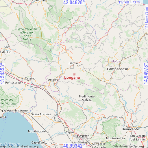
Longano GPS coordinates[2]
41° 31' 19.164" North, 14° 14' 47.94" East
| Map corner | latitude | longitude |
|---|---|---|
| Upper-left | 42.04628°, | 13.54353° |
| Center: | 41.52199°, | 14.24665° |
| Lower-right: | 40.99342°, | 14.94978° |
| Map W x H: | 117.1×117.1 km | = 72.8×72.8mi |
| max Lat: | 47.04031° ⇑74.6% North |
| Longano: | 41.52199° |
| min Lat: | ⇓25.4% South 35.50142° |
| min Long | Longano | max Long |
| 6.69888° | 14.24665° | 18.48682° |
| W 80.3%⇐ | ⇒19.7% E |
Elevation
Elevation of Longano is 671 m = 2201 ft, and this is 364.3 m = 1195 ft above average elevation for this country.
| Max E: |
2085 m = 6841 ft | 12.1% |
| Longano | 671 m 2201 ft | |
| Avg. | 306.7 m = 1006 ft | |
Min E: |
-4 m = -13 ft | 87.9% |
See also: Italy elevation on elevation.city.
Geographical zone
Longano is located in North temperate zone (between Tropic of Cancer and the Arctic Circle). Distance of this Northern Tropic circle is 2010.9 km =1249.5 mi to South.| Distance of | km | miles | from Longano |
|---|---|---|---|
| North Pole | 5390.2 | 3349.3 | to North |
| Arctic Circle | 2784.4 | 1730.1 | to North |
| Tropic Cancer | 2010.9 | 1249.5 | to South |
| Equator | 4616.8 | 2868.7 | to South |


Nearby cities:
15 places around Longano: (largest is in red/bold)
• Castelpetroso
9.3 km =5.8 mi,  62°
62°
• Castelpizzuto
3.8 km =2.4 mi,  91°
91°
• Fontegreca
9 km =5.6 mi,  215°
215°
• Gallo
6.6 km =4.1 mi,  195°
195°
• Gallo Matese
6.6 km =4.1 mi, 195°
• Indiprete
8.2 km =5.1 mi,  70°
70°
• Isernia
8.3 km =5.2 mi,  352°
352°
• Letino
7.7 km =4.8 mi,  174°
174°
• Macchia d'Isernia
7.7 km =4.8 mi,  303°
303°
• Monteroduni
5.8 km =3.6 mi,  270°
270°
• Pesche
9.6 km =6 mi,  14°
14°
• Pettoranello del Molise
6.3 km =3.9 mi,  24°
24°
• Roccamandolfi
9.3 km =5.8 mi,  108°
108°
• Sant'Agapito
3.2 km =2 mi,  319°
319°
• Sant'Eusanio
8 km =5 mi,  275°
275°
Sources, notices
• [Note1] Compared only with cities in Italy existing in our database
• [Src1] Map data: © OpenStreetMap contributors (CC-BY-SA)
• [Src2] Other city data from geonames.org with taken over terms of usage.
• [Src3] Geographical zone / Annual Mean Temperature by Robert A. Rohde @ Wikipedia
