La Rosa geodata
La Rosa (Apulia) is a populated place; located in Italy in Europe/Rome (GMT+2) time zone. With population of 1,313 people, there are 5588 cities with bigger population in this country. Compared to other cities in Italy, 83.4% of cities are located further ↑North; 98.8% of cities are located further ←West and 87.8% of cities have higher elevation than La Rosa. Note1


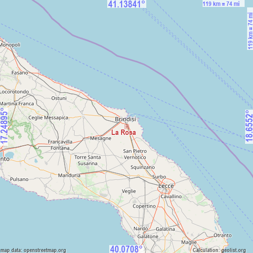
La Rosa GPS coordinates[2]
40° 36' 24.264" North, 17° 57' 7.452" East
| Map corner | latitude | longitude |
|---|---|---|
| Upper-left | 41.13841°, | 17.24895° |
| Center: | 40.60674°, | 17.95207° |
| Lower-right: | 40.0708°, | 18.6552° |
| Map W x H: | 118.7×118.7 km | = 73.8×73.8mi |
| max Lat: | 47.04031° ⇑83.4% North |
| La Rosa: | 40.60674° |
| min Lat: | ⇓16.6% South 35.50142° |
| min Long | La Rosa | max Long |
| 6.69888° | 17.95207° | 18.48682° |
| W 98.8%⇐ | ⇒1.2% E |
Elevation
Elevation of La Rosa is 23 m = 75 ft, and this is 283.7 m = 931 ft below average elevation for this country.
| Max E: |
2085 m = 6841 ft | 87.8% |
| Avg. | 306.7 m = 1006 ft | |
| La Rosa | 23 m = 75 ft | |
Min E: |
-4 m = -13 ft | 12.2% |
See also: Italy elevation on elevation.city.
Geographical zone
La Rosa is located in North temperate zone (between Tropic of Cancer and the Arctic Circle). Distance of this Northern Tropic circle is 1909.1 km =1186.3 mi to South.| Distance of | km | miles | from La Rosa |
|---|---|---|---|
| North Pole | 5492 | 3412.6 | to North |
| Arctic Circle | 2886.1 | 1793.3 | to North |
| Tropic Cancer | 1909.1 | 1186.3 | to South |
| Equator | 4515 | 2805.5 | to South |


Nearby cities:
15 places around La Rosa: (largest is in red/bold)
• Betlemme
7.4 km =4.6 mi,  352°
352°
• Brindisi
3.1 km =1.9 mi,  334°
334°
• Cellino San Marco
15.1 km =9.4 mi,  176°
176°
• Guagnano
22.9 km =14.2 mi, 180°
• Latiano
20.7 km =12.9 mi,  252°
252°
• Materdomini
5.5 km =3.4 mi,  6°
6°
• Mesagne
13.3 km =8.3 mi, 246°
• San Donaci
17.8 km =11.1 mi,  188°
188°
• San Pancrazio Salentino
23.2 km =14.4 mi,  205°
205°
• San Pietro Vernotico
13.7 km =8.5 mi,  163°
163°
• San Vito dei Normanni
21.3 km =13.2 mi,  285°
285°
• Squinzano
20.5 km =12.7 mi, 158°
• Torchiarolo
16.1 km =10 mi,  148°
148°
• Tuturano
6.9 km =4.3 mi, 183°
• Villa Baldassarri
21.2 km =13.2 mi, 177°
Sources, notices
• [Note1] Compared only with cities in Italy existing in our database
• [Src1] Map data: © OpenStreetMap contributors (CC-BY-SA)
• [Src2] Other city data from geonames.org with taken over terms of usage.
• [Src3] Geographical zone / Annual Mean Temperature by Robert A. Rohde @ Wikipedia
