Tuturano geodata
Tuturano (Apulia) is a populated place; located in Italy in Europe/Rome (GMT+2) time zone. With population of 3,045 people, there are 3000 cities with bigger population in this country. Compared to other cities in Italy, 83.9% of cities are located further ↑North; 98.8% of cities are located further ←West and 80.9% of cities have higher elevation than Tuturano. Note1


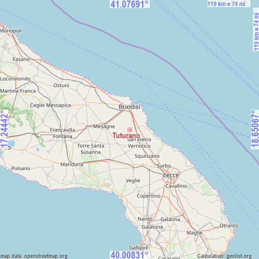
Tuturano GPS coordinates[2]
40° 32' 41.064" North, 17° 56' 51.144" East
| Map corner | latitude | longitude |
|---|---|---|
| Upper-left | 41.07691°, | 17.24442° |
| Center: | 40.54474°, | 17.94754° |
| Lower-right: | 40.00831°, | 18.65067° |
| Map W x H: | 118.8×118.8 km | = 73.8×73.8mi |
| max Lat: | 47.04031° ⇑83.9% North |
| Tuturano: | 40.54474° |
| min Lat: | ⇓16.1% South 35.50142° |
| min Long | Tuturano | max Long |
| 6.69888° | 17.94754° | 18.48682° |
| W 98.8%⇐ | ⇒1.2% E |
Elevation
Elevation of Tuturano is 46 m = 151 ft, and this is 260.7 m = 855 ft below average elevation for this country.
| Max E: |
2085 m = 6841 ft | 80.9% |
| Avg. | 306.7 m = 1006 ft | |
| Tuturano | 46 m = 151 ft | |
Min E: |
-4 m = -13 ft | 19.1% |
See also: Italy elevation on elevation.city.
Geographical zone
Tuturano is located in North temperate zone (between Tropic of Cancer and the Arctic Circle). Distance of this Northern Tropic circle is 1902.2 km =1182 mi to South.| Distance of | km | miles | from Tuturano |
|---|---|---|---|
| North Pole | 5498.9 | 3416.9 | to North |
| Arctic Circle | 2893 | 1797.6 | to North |
| Tropic Cancer | 1902.2 | 1182 | to South |
| Equator | 4508.2 | 2801.3 | to South |


Nearby cities:
15 places around Tuturano: (largest is in red/bold)
• Betlemme
14.2 km =8.8 mi,  357°
357°
• Brindisi
9.8 km =6.1 mi,  354°
354°
• Campi Salentina
17.5 km =10.9 mi,  159°
159°
• Cellino San Marco
8.3 km =5.2 mi,  170°
170°
• Guagnano
16 km =9.9 mi,  179°
179°
• La Rosa
6.9 km =4.3 mi,  3°
3°
• Materdomini
12.4 km =7.7 mi, 4°
• Mesagne
11.9 km =7.4 mi,  277°
277°
• Salice Salentino
17.8 km =11.1 mi, 176°
• San Donaci
10.9 km =6.8 mi,  191°
191°
• San Pancrazio Salentino
17 km =10.6 mi,  214°
214°
• San Pietro Vernotico
7.5 km =4.7 mi,  145°
145°
• Squinzano
14.5 km =9 mi, 147°
• Torchiarolo
11.1 km =6.9 mi,  127°
127°
• Villa Baldassarri
14.4 km =8.9 mi, 174°
Sources, notices
• [Note1] Compared only with cities in Italy existing in our database
• [Src1] Map data: © OpenStreetMap contributors (CC-BY-SA)
• [Src2] Other city data from geonames.org with taken over terms of usage.
• [Src3] Geographical zone / Annual Mean Temperature by Robert A. Rohde @ Wikipedia
