Carraia geodata
Carraia (Tuscany) is a populated place; located in Italy in Europe/Rome (GMT+2) time zone. With population of 1,201 people, there are 5953 cities with bigger population in this country. Compared to other cities in Italy, 55.8% of cities are located further ↑North; 54.7% of cities are located further →East and 68.3% of cities have higher elevation than Carraia. Note1


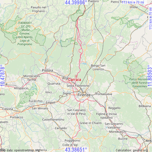
Carraia GPS coordinates[2]
43° 53' 43.224" North, 11° 10' 54.84" East
| Map corner | latitude | longitude |
|---|---|---|
| Upper-left | 44.39986°, | 10.47878° |
| Center: | 43.89534°, | 11.1819° |
| Lower-right: | 43.38651°, | 11.88503° |
| Map W x H: | 112.7×112.7 km | = 70×70mi |
| max Lat: | 47.04031° ⇑55.8% North |
| Carraia: | 43.89534° |
| min Lat: | ⇓44.2% South 35.50142° |
| min Long | Carraia | max Long |
| 6.69888° | 11.1819° | 18.48682° |
| W 45.3%⇐ | ⇒54.7% E |
Elevation
Elevation of Carraia is 107 m = 351 ft, and this is 199.7 m = 655 ft below average elevation for this country.
| Max E: |
2085 m = 6841 ft | 68.3% |
| Avg. | 306.7 m = 1006 ft | |
| Carraia | 107 m = 351 ft | |
Min E: |
-4 m = -13 ft | 31.7% |
See also: Italy elevation on elevation.city.
Geographical zone
Carraia is located in North temperate zone (between Tropic of Cancer and the Arctic Circle). Distance of this Northern Tropic circle is 2274.8 km =1413.5 mi to South.| Distance of | km | miles | from Carraia |
|---|---|---|---|
| North Pole | 5126.4 | 3185.4 | to North |
| Arctic Circle | 2520.5 | 1566.2 | to North |
| Tropic Cancer | 2274.8 | 1413.5 | to South |
| Equator | 4880.7 | 3032.7 | to South |


Nearby cities:
15 places around Carraia: (largest is in red/bold)
• Bivigliano
11.1 km =6.9 mi,  89°
89°
• Calenzano
4.7 km =2.9 mi,  195°
195°
• Campi Bisenzio
8.9 km =5.5 mi,  207°
207°
• Cavallina
10.6 km =6.6 mi,  22°
22°
• Il Fabbro
10.4 km =6.5 mi,  334°
334°
• Il Rosi
5.4 km =3.4 mi,  217°
217°
• Pian di San Bartolo-Trespiano
10.9 km =6.8 mi,  128°
128°
• Prato
7 km =4.3 mi,  256°
256°
• Pratolino
10.1 km =6.3 mi,  111°
111°
• San Donnino
11.5 km =7.1 mi,  194°
194°
• San Mauro
12.1 km =7.5 mi, 202°
• Schignano
9.8 km =6.1 mi,  321°
321°
• Sesto Fiorentino
7.2 km =4.5 mi,  168°
168°
• Vaglia
8 km =5 mi,  77°
77°
• Vaiano
9.3 km =5.8 mi, 330°
Sources, notices
• [Note1] Compared only with cities in Italy existing in our database
• [Src1] Map data: © OpenStreetMap contributors (CC-BY-SA)
• [Src2] Other city data from geonames.org with taken over terms of usage.
• [Src3] Geographical zone / Annual Mean Temperature by Robert A. Rohde @ Wikipedia
