San Fele geodata
San Fele (Basilicate) is a seat of a third-order administrative division; located in Italy in Europe/Rome (GMT+2) time zone. With population of 1,137 people, there are 6159 cities with bigger population in this country. Compared to other cities in Italy, 81.2% of cities are located further ↑North; 90.7% of cities are located further ←West and 95.2% of cities have lower elevation than San Fele. Note1


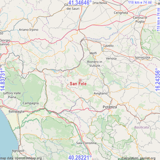
San Fele GPS coordinates[2]
40° 48' 59.292" North, 15° 32' 25.548" East
| Map corner | latitude | longitude |
|---|---|---|
| Upper-left | 41.34646°, | 14.83731° |
| Center: | 40.81647°, | 15.54043° |
| Lower-right: | 40.28221°, | 16.24356° |
| Map W x H: | 118.3×118.3 km | = 73.5×73.5mi |
| max Lat: | 47.04031° ⇑81.2% North |
| San Fele: | 40.81647° |
| min Lat: | ⇓18.8% South 35.50142° |
| min Long | San Fele | max Long |
| 6.69888° | 15.54043° | 18.48682° |
| W 90.7%⇐ | ⇒9.3% E |
Elevation
Elevation of San Fele is 884 m = 2900 ft, and this is 577.3 m = 1894 ft above average elevation for this country.
| Max E: |
2085 m = 6841 ft | 4.8% |
| San Fele | 884 m 2900 ft | |
| Avg. | 306.7 m = 1006 ft | |
Min E: |
-4 m = -13 ft | 95.2% |
See also: Italy elevation on elevation.city.
Geographical zone
San Fele is located in North temperate zone (between Tropic of Cancer and the Arctic Circle). Distance of this Northern Tropic circle is 1932.4 km =1200.7 mi to South.| Distance of | km | miles | from San Fele |
|---|---|---|---|
| North Pole | 5468.7 | 3398.1 | to North |
| Arctic Circle | 2862.8 | 1778.9 | to North |
| Tropic Cancer | 1932.4 | 1200.7 | to South |
| Equator | 4538.4 | 2820 | to South |


Nearby cities:
15 places around San Fele: (largest is in red/bold)
• Atella
11.7 km =7.3 mi,  53°
53°
• Baragiano
15.8 km =9.8 mi,  163°
163°
• Bella
6.2 km =3.9 mi,  179°
179°
• Castelgrande
9.8 km =6.1 mi,  250°
250°
• Filiano
14.3 km =8.9 mi,  92°
92°
• Lagopesole
16.4 km =10.2 mi,  95°
95°
• Muro Lucano
8.2 km =5.1 mi,  212°
212°
• Pescopagano
12 km =7.5 mi,  279°
279°
• Rapone
4.9 km =3 mi,  313°
313°
• Rionero in Vulture
16.2 km =10.1 mi,  42°
42°
• Ruvo del Monte
3.7 km =2.3 mi,  2°
2°
• San Cataldo
13.4 km =8.3 mi,  128°
128°
• Sant'Andrea di Conza
14.7 km =9.1 mi, 282°
• Scalera
15.8 km =9.8 mi,  72°
72°
• Scalo di Baragiano
13.8 km =8.6 mi,  167°
167°
Sources, notices
• [Note1] Compared only with cities in Italy existing in our database
• [Src1] Map data: © OpenStreetMap contributors (CC-BY-SA)
• [Src2] Other city data from geonames.org with taken over terms of usage.
• [Src3] Geographical zone / Annual Mean Temperature by Robert A. Rohde @ Wikipedia
