Senise geodata
Senise (Basilicate) is a seat of a third-order administrative division; located in Italy in Europe/Rome (GMT+2) time zone. With population of 6,243 people, there are 1562 cities with bigger population in this country. Compared to other cities in Italy, 86.8% of cities are located further ↑North; 95.1% of cities are located further ←West and 65.7% of cities have lower elevation than Senise. Note1


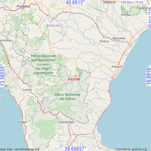
Senise GPS coordinates[2]
40° 8' 46.176" North, 16° 17' 19.212" East
| Map corner | latitude | longitude |
|---|---|---|
| Upper-left | 40.6815°, | 15.58555° |
| Center: | 40.14616°, | 16.28867° |
| Lower-right: | 39.60657°, | 16.9918° |
| Map W x H: | 119.5×119.5 km | = 74.3×74.3mi |
| max Lat: | 47.04031° ⇑86.8% North |
| Senise: | 40.14616° |
| min Lat: | ⇓13.2% South 35.50142° |
| min Long | Senise | max Long |
| 6.69888° | 16.28867° | 18.48682° |
| W 95.1%⇐ | ⇒4.9% E |
Elevation
Elevation of Senise is 350 m = 1148 ft, and this is 43.3 m = 142 ft above average elevation for this country.
| Max E: |
2085 m = 6841 ft | 34.3% |
| Senise | 350 m 1148 ft | |
| Avg. | 306.7 m = 1006 ft | |
Min E: |
-4 m = -13 ft | 65.7% |
See also: Italy elevation on elevation.city.
Geographical zone
Senise is located in North temperate zone (between Tropic of Cancer and the Arctic Circle). Distance of this Northern Tropic circle is 1857.9 km =1154.4 mi to South.| Distance of | km | miles | from Senise |
|---|---|---|---|
| North Pole | 5543.2 | 3444.4 | to North |
| Arctic Circle | 2937.3 | 1825.2 | to North |
| Tropic Cancer | 1857.9 | 1154.4 | to South |
| Equator | 4463.8 | 2773.7 | to South |


Nearby cities:
15 places around Senise: (largest is in red/bold)
• Calvera
12.3 km =7.6 mi,  271°
271°
• Castronuovo di Sant'Andrea
10 km =6.2 mi,  298°
298°
• Cersosimo
12.2 km =7.6 mi,  154°
154°
• Chiaromonte
6.8 km =4.2 mi,  248°
248°
• Colobraro
12.5 km =7.8 mi,  67°
67°
• Fardella
10.7 km =6.6 mi, 250°
• Francavilla in Sinni
10.2 km =6.3 mi,  224°
224°
• Noepoli
7.4 km =4.6 mi, 152°
• Roccanova
10.3 km =6.4 mi,  315°
315°
• San Brancato
12.8 km =8 mi,  347°
347°
• San Costantino Albanese
12.2 km =7.6 mi,  173°
173°
• San Giorgio Lucano
9.4 km =5.8 mi,  114°
114°
• San Paolo Albanese
12.9 km =8 mi,  162°
162°
• Sant'Arcangelo
11.5 km =7.1 mi, 352°
• Teana
11.8 km =7.3 mi,  258°
258°
Sources, notices
• [Note1] Compared only with cities in Italy existing in our database
• [Src1] Map data: © OpenStreetMap contributors (CC-BY-SA)
• [Src2] Other city data from geonames.org with taken over terms of usage.
• [Src3] Geographical zone / Annual Mean Temperature by Robert A. Rohde @ Wikipedia
