Chiaromonte geodata
Chiaromonte (Basilicate) is a seat of a third-order administrative division; located in Italy in Europe/Rome (GMT+2) time zone. With population of 1,191 people, there are 5986 cities with bigger population in this country. Compared to other cities in Italy, 86.9% of cities are located further ↑North; 94.5% of cities are located further ←West and 90.7% of cities have lower elevation than Chiaromonte. Note1


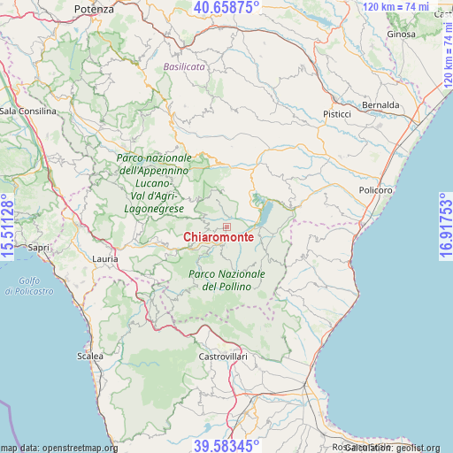
Chiaromonte GPS coordinates[2]
40° 7' 23.628" North, 16° 12' 51.84" East
| Map corner | latitude | longitude |
|---|---|---|
| Upper-left | 40.65875°, | 15.51128° |
| Center: | 40.12323°, | 16.2144° |
| Lower-right: | 39.58345°, | 16.91753° |
| Map W x H: | 119.6×119.6 km | = 74.3×74.3mi |
| max Lat: | 47.04031° ⇑86.9% North |
| Chiaromonte: | 40.12323° |
| min Lat: | ⇓13.1% South 35.50142° |
| min Long | Chiaromonte | max Long |
| 6.69888° | 16.2144° | 18.48682° |
| W 94.5%⇐ | ⇒5.5% E |
Elevation
Elevation of Chiaromonte is 736 m = 2415 ft, and this is 429.3 m = 1408 ft above average elevation for this country.
| Max E: |
2085 m = 6841 ft | 9.3% |
| Chiaromonte | 736 m 2415 ft | |
| Avg. | 306.7 m = 1006 ft | |
Min E: |
-4 m = -13 ft | 90.7% |
See also: Italy elevation on elevation.city.
Geographical zone
Chiaromonte is located in North temperate zone (between Tropic of Cancer and the Arctic Circle). Distance of this Northern Tropic circle is 1855.4 km =1152.9 mi to South.| Distance of | km | miles | from Chiaromonte |
|---|---|---|---|
| North Pole | 5545.8 | 3446 | to North |
| Arctic Circle | 2939.9 | 1826.8 | to North |
| Tropic Cancer | 1855.4 | 1152.9 | to South |
| Equator | 4461.3 | 2772.1 | to South |


Nearby cities:
15 places around Chiaromonte: (largest is in red/bold)
• Calvera
6.7 km =4.2 mi,  295°
295°
• Carbone
10.9 km =6.8 mi,  281°
281°
• Castronuovo di Sant'Andrea
7.7 km =4.8 mi,  341°
341°
• Cersosimo
14.4 km =8.9 mi,  126°
126°
• Episcopia
11.3 km =7 mi,  241°
241°
• Fardella
3.9 km =2.4 mi,  254°
254°
• Francavilla in Sinni
4.7 km =2.9 mi,  190°
190°
• Noepoli
10.5 km =6.5 mi,  112°
112°
• Roccanova
10 km =6.2 mi,  355°
355°
• San Chirico Raparo
14 km =8.7 mi, 303°
• San Costantino Albanese
12.3 km =7.6 mi,  141°
141°
• San Paolo Albanese
14.1 km =8.8 mi, 133°
• San Severino Lucano
13.1 km =8.1 mi,  209°
209°
• Senise
6.8 km =4.2 mi,  68°
68°
• Teana
5.2 km =3.2 mi,  273°
273°
Sources, notices
• [Note1] Compared only with cities in Italy existing in our database
• [Src1] Map data: © OpenStreetMap contributors (CC-BY-SA)
• [Src2] Other city data from geonames.org with taken over terms of usage.
• [Src3] Geographical zone / Annual Mean Temperature by Robert A. Rohde @ Wikipedia
