Salmour geodata
Salmour (Piedmont) is a seat of a third-order administrative division; located in Italy in Europe/Rome (GMT+2) time zone. With population of 366 people, there are 10407 cities with bigger population in this country. Compared to other cities in Italy, 52.1% of cities are located further ↓South; 95.6% of cities are located further →East and 69.4% of cities have lower elevation than Salmour. Note1


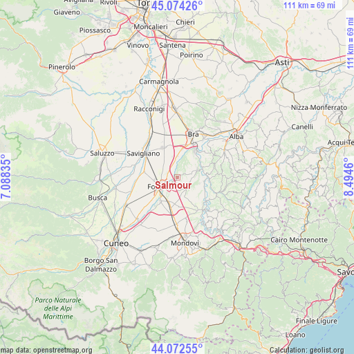
Salmour GPS coordinates[2]
44° 34' 32.016" North, 7° 47' 29.328" East
| Map corner | latitude | longitude |
|---|---|---|
| Upper-left | 45.07426°, | 7.08835° |
| Center: | 44.57556°, | 7.79148° |
| Lower-right: | 44.07255°, | 8.4946° |
| Map W x H: | 111.4×111.4 km | = 69.2×69.2mi |
| max Lat: | 47.04031° ⇑47.9% North |
| Salmour: | 44.57556° |
| min Lat: | ⇓52.1% South 35.50142° |
| min Long | Salmour | max Long |
| 6.69888° | 7.79148° | 18.48682° |
| W 4.4%⇐ | ⇒95.6% E |
Elevation
Elevation of Salmour is 389 m = 1276 ft, and this is 82.3 m = 270 ft above average elevation for this country.
| Max E: |
2085 m = 6841 ft | 30.6% |
| Salmour | 389 m 1276 ft | |
| Avg. | 306.7 m = 1006 ft | |
Min E: |
-4 m = -13 ft | 69.4% |
See also: Italy elevation on elevation.city.
Geographical zone
Salmour is located in North temperate zone (between Tropic of Cancer and the Arctic Circle). Distance of this Northern Tropic circle is 2350.4 km =1460.5 mi to South.| Distance of | km | miles | from Salmour |
|---|---|---|---|
| North Pole | 5050.7 | 3138.4 | to North |
| Arctic Circle | 2444.8 | 1519.1 | to North |
| Tropic Cancer | 2350.4 | 1460.5 | to South |
| Equator | 4956.3 | 3079.7 | to South |


Nearby cities:
15 places around Salmour: (largest is in red/bold)
• Bene Vagienna
4.6 km =2.9 mi,  142°
142°
• Bricco Favole
9 km =5.6 mi,  10°
10°
• Cervere
6.5 km =4 mi,  358°
358°
• Cherasco
9.2 km =5.7 mi,  34°
34°
• Fossano
6.4 km =4 mi,  244°
244°
• Genola
10.5 km =6.5 mi,  279°
279°
• Lequio Tanaro
7.4 km =4.6 mi,  103°
103°
• Marene
10.5 km =6.5 mi,  334°
334°
• Monchiero Borgonuovo
10.2 km =6.3 mi,  93°
93°
• Narzole
6.4 km =4 mi,  70°
70°
• Novello
10.7 km =6.6 mi,  82°
82°
• Piozzo
10.5 km =6.5 mi,  130°
130°
• Roreto
11 km =6.8 mi,  17°
17°
• Sant'Albano Stura
9.3 km =5.8 mi,  215°
215°
• Trinità
8.1 km =5 mi,  200°
200°
Sources, notices
• [Note1] Compared only with cities in Italy existing in our database
• [Src1] Map data: © OpenStreetMap contributors (CC-BY-SA)
• [Src2] Other city data from geonames.org with taken over terms of usage.
• [Src3] Geographical zone / Annual Mean Temperature by Robert A. Rohde @ Wikipedia
