Cherasco geodata
Cherasco (Piedmont) is a seat of a third-order administrative division; located in Italy in Europe/Rome (GMT+2) time zone. With population of 3,406 people, there are 2752 cities with bigger population in this country. Compared to other cities in Italy, 53.2% of cities are located further ↓South; 95.1% of cities are located further →East and 58.6% of cities have lower elevation than Cherasco. Note1


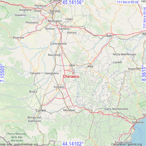
Cherasco GPS coordinates[2]
44° 38' 36.42" North, 7° 51' 29.448" East
| Map corner | latitude | longitude |
|---|---|---|
| Upper-left | 45.14156°, | 7.15505° |
| Center: | 44.64345°, | 7.85818° |
| Lower-right: | 44.14102°, | 8.5613° |
| Map W x H: | 111.2×111.2 km | = 69.1×69.1mi |
| max Lat: | 47.04031° ⇑46.8% North |
| Cherasco: | 44.64345° |
| min Lat: | ⇓53.2% South 35.50142° |
| min Long | Cherasco | max Long |
| 6.69888° | 7.85818° | 18.48682° |
| W 4.9%⇐ | ⇒95.1% E |
Elevation
Elevation of Cherasco is 289 m = 948 ft, and this is 17.7 m = 58 ft below average elevation for this country.
| Max E: |
2085 m = 6841 ft | 41.4% |
| Avg. | 306.7 m = 1006 ft | |
| Cherasco | 289 m = 948 ft | |
Min E: |
-4 m = -13 ft | 58.6% |
See also: Italy elevation on elevation.city.
Geographical zone
Cherasco is located in North temperate zone (between Tropic of Cancer and the Arctic Circle). Distance of this Northern Tropic circle is 2358 km =1465.2 mi to South.| Distance of | km | miles | from Cherasco |
|---|---|---|---|
| North Pole | 5043.2 | 3133.7 | to North |
| Arctic Circle | 2437.3 | 1514.5 | to North |
| Tropic Cancer | 2358 | 1465.2 | to South |
| Equator | 4963.9 | 3084.4 | to South |


Nearby cities:
15 places around Cherasco: (largest is in red/bold)
• Barolo
7.6 km =4.7 mi,  118°
118°
• Borgo San Martino
6.7 km =4.2 mi,  20°
20°
• Bra
6.1 km =3.8 mi,  354°
354°
• Bricco Favole
3.9 km =2.4 mi,  289°
289°
• Cervere
5.6 km =3.5 mi,  259°
259°
• Cinzano
7.4 km =4.6 mi,  42°
42°
• La Morra
5.8 km =3.6 mi,  96°
96°
• Narzole
5.5 km =3.4 mi,  172°
172°
• Novello
8.1 km =5 mi,  138°
138°
• Pocapaglia
8.2 km =5.1 mi,  13°
13°
• Pollenzo
5.6 km =3.5 mi,  31°
31°
• Roreto
3.4 km =2.1 mi,  326°
326°
• Santa Vittoria d'Alba
8.8 km =5.5 mi,  45°
45°
• Verduno
6.3 km =3.9 mi,  66°
66°
• Villa-Borgo
8.6 km =5.3 mi, 44°
Sources, notices
• [Note1] Compared only with cities in Italy existing in our database
• [Src1] Map data: © OpenStreetMap contributors (CC-BY-SA)
• [Src2] Other city data from geonames.org with taken over terms of usage.
• [Src3] Geographical zone / Annual Mean Temperature by Robert A. Rohde @ Wikipedia
