Genola geodata
Genola (Piedmont) is a seat of a third-order administrative division; located in Italy in Europe/Rome (GMT+2) time zone. With population of 2,186 people, there are 3891 cities with bigger population in this country. Compared to other cities in Italy, 52.4% of cities are located further ↓South; 96.6% of cities are located further →East and 64.9% of cities have lower elevation than Genola. Note1


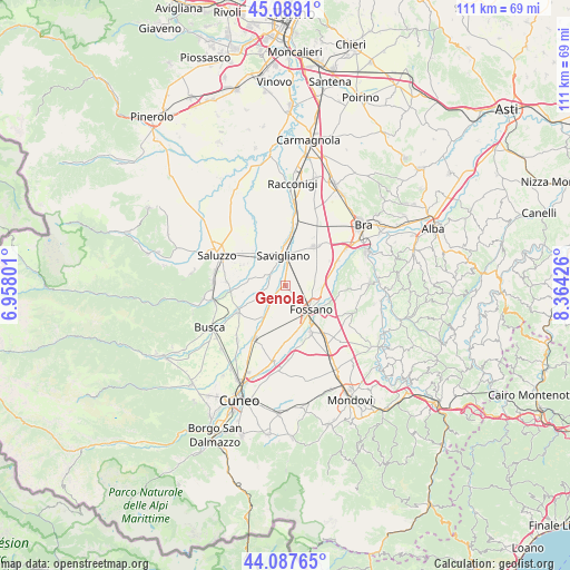
Genola GPS coordinates[2]
44° 35' 25.908" North, 7° 39' 40.104" East
| Map corner | latitude | longitude |
|---|---|---|
| Upper-left | 45.0891°, | 6.95801° |
| Center: | 44.59053°, | 7.66114° |
| Lower-right: | 44.08765°, | 8.36426° |
| Map W x H: | 111.4×111.3 km | = 69.2×69.2mi |
| max Lat: | 47.04031° ⇑47.6% North |
| Genola: | 44.59053° |
| min Lat: | ⇓52.4% South 35.50142° |
| min Long | Genola | max Long |
| 6.69888° | 7.66114° | 18.48682° |
| W 3.4%⇐ | ⇒96.6% E |
Elevation
Elevation of Genola is 342 m = 1122 ft, and this is 35.3 m = 116 ft above average elevation for this country.
| Max E: |
2085 m = 6841 ft | 35.1% |
| Genola | 342 m 1122 ft | |
| Avg. | 306.7 m = 1006 ft | |
Min E: |
-4 m = -13 ft | 64.9% |
See also: Italy elevation on elevation.city.
Geographical zone
Genola is located in North temperate zone (between Tropic of Cancer and the Arctic Circle). Distance of this Northern Tropic circle is 2352.1 km =1461.5 mi to South.| Distance of | km | miles | from Genola |
|---|---|---|---|
| North Pole | 5049.1 | 3137.4 | to North |
| Arctic Circle | 2443.2 | 1518.1 | to North |
| Tropic Cancer | 2352.1 | 1461.5 | to South |
| Equator | 4958 | 3080.8 | to South |


Nearby cities:
15 places around Genola: (largest is in red/bold)
• Centallo
11.5 km =7.1 mi,  210°
210°
• Cervere
11.2 km =7 mi,  64°
64°
• Fossano
6.4 km =4 mi,  133°
133°
• Lagnasco
9.2 km =5.7 mi,  294°
294°
• Levaldigi
4.8 km =3 mi,  219°
219°
• Marene
9.8 km =6.1 mi,  36°
36°
• Monasterolo di Savigliano
11.2 km =7 mi,  342°
342°
• Salmour
10.5 km =6.5 mi,  99°
99°
• San Biagio
12.7 km =7.9 mi,  198°
198°
• Sant'Albano Stura
10.4 km =6.5 mi,  152°
152°
• Savigliano
6.4 km =4 mi,  356°
356°
• Scarnafigi
12.5 km =7.8 mi,  322°
322°
• Trinità
11.9 km =7.4 mi,  140°
140°
• Villafalletto
10.7 km =6.6 mi,  242°
242°
• Vottignasco
7.1 km =4.4 mi,  245°
245°
Sources, notices
• [Note1] Compared only with cities in Italy existing in our database
• [Src1] Map data: © OpenStreetMap contributors (CC-BY-SA)
• [Src2] Other city data from geonames.org with taken over terms of usage.
• [Src3] Geographical zone / Annual Mean Temperature by Robert A. Rohde @ Wikipedia
