Bardonecchia geodata
Bardonecchia (Piedmont) is a seat of a third-order administrative division; located in Italy in Europe/Rome (GMT+2) time zone. With population of 2,962 people, there are 3076 cities with bigger population in this country. Compared to other cities in Italy, 61.9% of cities are located further ↓South; 100% of cities are located further →East and 99.1% of cities have lower elevation than Bardonecchia. Note1


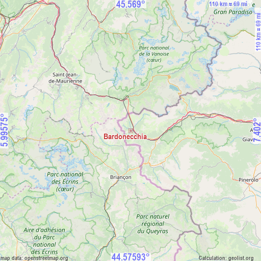
Bardonecchia GPS coordinates[2]
45° 4' 28.632" North, 6° 41' 55.968" East
| Map corner | latitude | longitude |
|---|---|---|
| Upper-left | 45.569°, | 5.99575° |
| Center: | 45.07462°, | 6.69888° |
| Lower-right: | 44.57593°, | 7.402° |
| Map W x H: | 110.4×110.4 km | = 68.6×68.6mi |
| max Lat: | 47.04031° ⇑38.1% North |
| Bardonecchia: | 45.07462° |
| min Lat: | ⇓61.9% South 35.50142° |
| min Long | Bardonecchia | max Long |
| 6.69888° | 6.69888° | 18.48682° |
| W 0%⇐ | ⇒100% E |
Elevation
Elevation of Bardonecchia is 1293 m = 4242 ft, and this is 986.3 m = 3236 ft above average elevation for this country.
| Max E: |
2085 m = 6841 ft | 0.90000000000001% |
| Bardonecchia | 1293 m 4242 ft | |
| Avg. | 306.7 m = 1006 ft | |
Min E: |
-4 m = -13 ft | 99.1% |
See also: Italy elevation on elevation.city.
Geographical zone
Bardonecchia is located in North temperate zone (between Tropic of Cancer and the Arctic Circle). Distance of this North polar circle is 2389.3 km =1484.6 mi to North.| Distance of | km | miles | from Bardonecchia |
|---|---|---|---|
| North Pole | 4995.2 | 3103.9 | to North |
| Arctic Circle | 2389.3 | 1484.6 | to North |
| Tropic Cancer | 2405.9 | 1495 | to South |
| Equator | 5011.8 | 3114.2 | to South |


Nearby cities:
15 places around Bardonecchia: (largest is in red/bold)
• Cesana Torinese
15.3 km =9.5 mi,  151°
151°
• Chiomonte
22.9 km =14.2 mi,  77°
77°
• Claviere
15.6 km =9.7 mi,  164°
164°
• Colle Sestriere
19.1 km =11.9 mi,  133°
133°
• Exilles
18.3 km =11.4 mi, 81°
• Giaglione
25.9 km =16.1 mi,  73°
73°
• Gravere
25.6 km =15.9 mi, 77°
• Oulx
11.4 km =7.1 mi,  111°
111°
• Pragelato-Ruà
20.2 km =12.6 mi, 109°
• Salbertrand
14.8 km =9.2 mi,  90°
90°
• Sauze d'Oulx
13.8 km =8.6 mi, 112°
• Sauze di Cesana
19.6 km =12.2 mi,  139°
139°
• Sestriere
19.1 km =11.9 mi, 132°
• Usseaux
26 km =16.2 mi,  96°
96°
• Venaus
26.1 km =16.2 mi, 69°
Sources, notices
• [Note1] Compared only with cities in Italy existing in our database
• [Src1] Map data: © OpenStreetMap contributors (CC-BY-SA)
• [Src2] Other city data from geonames.org with taken over terms of usage.
• [Src3] Geographical zone / Annual Mean Temperature by Robert A. Rohde @ Wikipedia
