Londa geodata
Londa (Tuscany) is a seat of a third-order administrative division; located in Italy in Europe/Rome (GMT+2) time zone. With population of 1,377 people, there are 5415 cities with bigger population in this country. Compared to other cities in Italy, 56.2% of cities are located further ↑North; 50.3% of cities are located further ←West and 53.8% of cities have higher elevation than Londa. Note1


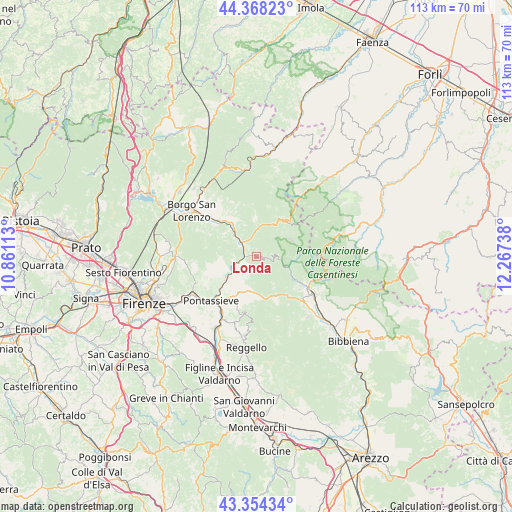
Londa GPS coordinates[2]
43° 51' 48.384" North, 11° 33' 51.3" East
| Map corner | latitude | longitude |
|---|---|---|
| Upper-left | 44.36823°, | 10.86113° |
| Center: | 43.86344°, | 11.56425° |
| Lower-right: | 43.35434°, | 12.26738° |
| Map W x H: | 112.7×112.7 km | = 70×70mi |
| max Lat: | 47.04031° ⇑56.2% North |
| Londa: | 43.86344° |
| min Lat: | ⇓43.8% South 35.50142° |
| min Long | Londa | max Long |
| 6.69888° | 11.56425° | 18.48682° |
| W 50.3%⇐ | ⇒49.7% E |
Elevation
Elevation of Londa is 211 m = 692 ft, and this is 95.7 m = 314 ft below average elevation for this country.
| Max E: |
2085 m = 6841 ft | 53.8% |
| Avg. | 306.7 m = 1006 ft | |
| Londa | 211 m = 692 ft | |
Min E: |
-4 m = -13 ft | 46.2% |
See also: Italy elevation on elevation.city.
Geographical zone
Londa is located in North temperate zone (between Tropic of Cancer and the Arctic Circle). Distance of this Northern Tropic circle is 2271.2 km =1411.3 mi to South.| Distance of | km | miles | from Londa |
|---|---|---|---|
| North Pole | 5129.9 | 3187.6 | to North |
| Arctic Circle | 2524 | 1568.3 | to North |
| Tropic Cancer | 2271.2 | 1411.3 | to South |
| Equator | 4877.2 | 3030.6 | to South |


Nearby cities:
15 places around Londa: (largest is in red/bold)
• Diacceto
10.1 km =6.3 mi,  209°
209°
• Dicomano
4.7 km =2.9 mi,  313°
313°
• I filipponi
0.5 km =0.3 mi,  297°
297°
• Molino del Piano
14.4 km =8.9 mi,  246°
246°
• Montebonello
7.2 km =4.5 mi,  239°
239°
• Montemignaio
14.4 km =8.9 mi,  162°
162°
• Pelago
11.3 km =7 mi, 206°
• Rufina
7.6 km =4.7 mi,  234°
234°
• San Francesco
13.5 km =8.4 mi,  223°
223°
• San Godenzo
8.2 km =5.1 mi,  33°
33°
• Sandetole
2.6 km =1.6 mi,  275°
275°
• Santa Brigida
13.4 km =8.3 mi,  264°
264°
• Stia
13.7 km =8.5 mi,  121°
121°
• Tosi
13 km =8.1 mi,  191°
191°
• Vicchio
11.5 km =7.1 mi, 313°
Sources, notices
• [Note1] Compared only with cities in Italy existing in our database
• [Src1] Map data: © OpenStreetMap contributors (CC-BY-SA)
• [Src2] Other city data from geonames.org with taken over terms of usage.
• [Src3] Geographical zone / Annual Mean Temperature by Robert A. Rohde @ Wikipedia
