Carlantino geodata
Carlantino (Apulia) is a seat of a third-order administrative division; located in Italy in Europe/Rome (GMT+2) time zone. With population of 1,020 people, there are 6582 cities with bigger population in this country. Compared to other cities in Italy, 74% of cities are located further ↑North; 87% of cities are located further ←West and 81.5% of cities have lower elevation than Carlantino. Note1


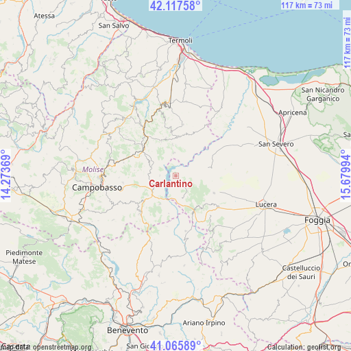
Carlantino GPS coordinates[2]
41° 35' 37.968" North, 14° 58' 36.516" East
| Map corner | latitude | longitude |
|---|---|---|
| Upper-left | 42.11758°, | 14.27369° |
| Center: | 41.59388°, | 14.97681° |
| Lower-right: | 41.06589°, | 15.67994° |
| Map W x H: | 116.9×116.9 km | = 72.6×72.6mi |
| max Lat: | 47.04031° ⇑74% North |
| Carlantino: | 41.59388° |
| min Lat: | ⇓26% South 35.50142° |
| min Long | Carlantino | max Long |
| 6.69888° | 14.97681° | 18.48682° |
| W 87%⇐ | ⇒13% E |
Elevation
Elevation of Carlantino is 546 m = 1791 ft, and this is 239.3 m = 785 ft above average elevation for this country.
| Max E: |
2085 m = 6841 ft | 18.5% |
| Carlantino | 546 m 1791 ft | |
| Avg. | 306.7 m = 1006 ft | |
Min E: |
-4 m = -13 ft | 81.5% |
See also: Italy elevation on elevation.city.
Geographical zone
Carlantino is located in North temperate zone (between Tropic of Cancer and the Arctic Circle). Distance of this Northern Tropic circle is 2018.9 km =1254.5 mi to South.| Distance of | km | miles | from Carlantino |
|---|---|---|---|
| North Pole | 5382.3 | 3344.4 | to North |
| Arctic Circle | 2776.4 | 1725.2 | to North |
| Tropic Cancer | 2018.9 | 1254.5 | to South |
| Equator | 4624.8 | 2873.7 | to South |


Nearby cities:
15 places around Carlantino: (largest is in red/bold)
• Bonefro
12.9 km =8 mi,  344°
344°
• Casalnuovo Monterotaro
11 km =6.8 mi,  74°
74°
• Casalvecchio di Puglia
11.1 km =6.9 mi,  89°
89°
• Castelnuovo della Daunia
11.8 km =7.3 mi,  96°
96°
• Celenza Valfortore
3.7 km =2.3 mi,  177°
177°
• Colletorto
7.6 km =4.7 mi,  354°
354°
• Gambatesa
10.9 km =6.8 mi,  209°
209°
• Macchia Valfortore
5.4 km =3.4 mi,  271°
271°
• Pietracatella
8.8 km =5.5 mi,  260°
260°
• San Giuliano di Puglia
10.5 km =6.5 mi, 353°
• San Marco la Catola
8.1 km =5 mi,  162°
162°
• Sant'Elia a Pianisi
8.9 km =5.5 mi,  289°
289°
• Santa Croce di Magliano
13.2 km =8.2 mi,  3°
3°
• Tufara
12.7 km =7.9 mi,  191°
191°
• Volturara Appula
12.6 km =7.8 mi,  150°
150°
Sources, notices
• [Note1] Compared only with cities in Italy existing in our database
• [Src1] Map data: © OpenStreetMap contributors (CC-BY-SA)
• [Src2] Other city data from geonames.org with taken over terms of usage.
• [Src3] Geographical zone / Annual Mean Temperature by Robert A. Rohde @ Wikipedia
