Rosciano geodata
Rosciano (Abruzzo) is a seat of a third-order administrative division; located in Italy in Europe/Rome (GMT+2) time zone. With population of 620 people, there are 8840 cities with bigger population in this country. Compared to other cities in Italy, 67.5% of cities are located further ↑North; 78.5% of cities are located further ←West and 51.9% of cities have lower elevation than Rosciano. Note1


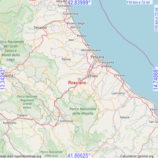
Rosciano GPS coordinates[2]
42° 19' 20.172" North, 14° 2' 43.98" East
| Map corner | latitude | longitude |
|---|---|---|
| Upper-left | 42.83999°, | 13.34243° |
| Center: | 42.32227°, | 14.04555° |
| Lower-right: | 41.80025°, | 14.74868° |
| Map W x H: | 115.6×115.6 km | = 71.8×71.8mi |
| max Lat: | 47.04031° ⇑67.5% North |
| Rosciano: | 42.32227° |
| min Lat: | ⇓32.5% South 35.50142° |
| min Long | Rosciano | max Long |
| 6.69888° | 14.04555° | 18.48682° |
| W 78.5%⇐ | ⇒21.5% E |
Elevation
Elevation of Rosciano is 246 m = 807 ft, and this is 60.7 m = 199 ft below average elevation for this country.
| Max E: |
2085 m = 6841 ft | 48.1% |
| Avg. | 306.7 m = 1006 ft | |
| Rosciano | 246 m = 807 ft | |
Min E: |
-4 m = -13 ft | 51.9% |
See also: Italy elevation on elevation.city.
Geographical zone
Rosciano is located in North temperate zone (between Tropic of Cancer and the Arctic Circle). Distance of this Northern Tropic circle is 2099.9 km =1304.8 mi to South.| Distance of | km | miles | from Rosciano |
|---|---|---|---|
| North Pole | 5301.3 | 3294.1 | to North |
| Arctic Circle | 2695.4 | 1674.8 | to North |
| Tropic Cancer | 2099.9 | 1304.8 | to South |
| Equator | 4705.8 | 2924 | to South |


Nearby cities:
15 places around Rosciano: (largest is in red/bold)
• Alanno
6.8 km =4.2 mi,  244°
244°
• Casalincontrada
7.9 km =4.9 mi,  110°
110°
• Catignano
8.2 km =5.1 mi,  289°
289°
• Cepagatti
5.3 km =3.3 mi,  26°
26°
• Lettomanoppello
8.8 km =5.5 mi,  183°
183°
• Manoppello
7.1 km =4.4 mi,  170°
170°
• Manoppello Scalo
1.8 km =1.1 mi,  157°
157°
• Nocciano
5.1 km =3.2 mi,  284°
284°
• Pianella
8.6 km =5.3 mi,  1°
1°
• Scafa
7.5 km =4.7 mi,  212°
212°
• Ticchione
4.4 km =2.7 mi,  219°
219°
• Tre Croci
5.2 km =3.2 mi,  40°
40°
• Turrivalignani
6.7 km =4.2 mi,  191°
191°
• Vallemare
5.9 km =3.7 mi,  55°
55°
• Villa Oliveti
2.5 km =1.6 mi, 44°
Sources, notices
• [Note1] Compared only with cities in Italy existing in our database
• [Src1] Map data: © OpenStreetMap contributors (CC-BY-SA)
• [Src2] Other city data from geonames.org with taken over terms of usage.
• [Src3] Geographical zone / Annual Mean Temperature by Robert A. Rohde @ Wikipedia
