Lettomanoppello geodata
Lettomanoppello (Abruzzo) is a seat of a third-order administrative division; located in Italy in Europe/Rome (GMT+2) time zone. With population of 3,019 people, there are 3026 cities with bigger population in this country. Compared to other cities in Italy, 68.3% of cities are located further ↑North; 78.4% of cities are located further ←West and 64.3% of cities have lower elevation than Lettomanoppello. Note1


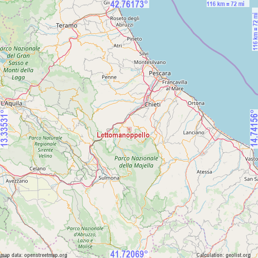
Lettomanoppello GPS coordinates[2]
42° 14' 36.096" North, 14° 2' 18.348" East
| Map corner | latitude | longitude |
|---|---|---|
| Upper-left | 42.76173°, | 13.33531° |
| Center: | 42.24336°, | 14.03843° |
| Lower-right: | 41.72069°, | 14.74156° |
| Map W x H: | 115.8×115.8 km | = 72×72mi |
| max Lat: | 47.04031° ⇑68.3% North |
| Lettomanoppello: | 42.24336° |
| min Lat: | ⇓31.7% South 35.50142° |
| min Long | Lettomanoppello | max Long |
| 6.69888° | 14.03843° | 18.48682° |
| W 78.4%⇐ | ⇒21.6% E |
Elevation
Elevation of Lettomanoppello is 337 m = 1106 ft, and this is 30.3 m = 99 ft above average elevation for this country.
| Max E: |
2085 m = 6841 ft | 35.7% |
| Lettomanoppello | 337 m 1106 ft | |
| Avg. | 306.7 m = 1006 ft | |
Min E: |
-4 m = -13 ft | 64.3% |
See also: Italy elevation on elevation.city.
Geographical zone
Lettomanoppello is located in North temperate zone (between Tropic of Cancer and the Arctic Circle). Distance of this Northern Tropic circle is 2091.1 km =1299.3 mi to South.| Distance of | km | miles | from Lettomanoppello |
|---|---|---|---|
| North Pole | 5310 | 3299.5 | to North |
| Arctic Circle | 2704.2 | 1680.3 | to North |
| Tropic Cancer | 2091.1 | 1299.3 | to South |
| Equator | 4697 | 2918.6 | to South |


Nearby cities:
15 places around Lettomanoppello: (largest is in red/bold)
• Abbateggio
3.2 km =2 mi,  227°
227°
• Alanno
8 km =5 mi,  316°
316°
• Bolognano
7 km =4.3 mi,  246°
246°
• Manoppello
2.5 km =1.6 mi,  45°
45°
• Manoppello Scalo
7.3 km =4.5 mi,  9°
9°
• Pretoro
9 km =5.6 mi,  107°
107°
• Roccamorice
3.6 km =2.2 mi,  197°
197°
• Rosciano
8.8 km =5.5 mi,  3°
3°
• San Rocco
7.4 km =4.6 mi,  90°
90°
• San Valentino in Abruzzo Citeriore
4.5 km =2.8 mi,  255°
255°
• Scafa
4.2 km =2.6 mi,  305°
305°
• Serramonacesca
4.5 km =2.8 mi,  83°
83°
• Ticchione
5.8 km =3.6 mi,  337°
337°
• Torre de' Passeri
8.7 km =5.4 mi,  269°
269°
• Turrivalignani
2.3 km =1.4 mi, 339°
Sources, notices
• [Note1] Compared only with cities in Italy existing in our database
• [Src1] Map data: © OpenStreetMap contributors (CC-BY-SA)
• [Src2] Other city data from geonames.org with taken over terms of usage.
• [Src3] Geographical zone / Annual Mean Temperature by Robert A. Rohde @ Wikipedia
