Alanno geodata
Alanno (Abruzzo) is a seat of a third-order administrative division; located in Italy in Europe/Rome (GMT+2) time zone. With population of 754 people, there are 7924 cities with bigger population in this country. Compared to other cities in Italy, 67.8% of cities are located further ↑North; 78% of cities are located further ←West and 57.9% of cities have lower elevation than Alanno. Note1


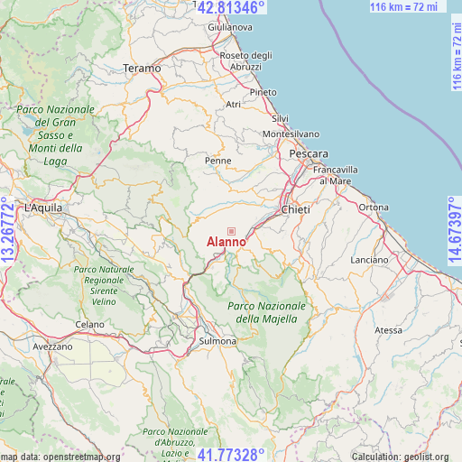
Alanno GPS coordinates[2]
42° 17' 43.872" North, 13° 58' 15.024" East
| Map corner | latitude | longitude |
|---|---|---|
| Upper-left | 42.81346°, | 13.26772° |
| Center: | 42.29552°, | 13.97084° |
| Lower-right: | 41.77328°, | 14.67397° |
| Map W x H: | 115.7×115.7 km | = 71.9×71.9mi |
| max Lat: | 47.04031° ⇑67.8% North |
| Alanno: | 42.29552° |
| min Lat: | ⇓32.2% South 35.50142° |
| min Long | Alanno | max Long |
| 6.69888° | 13.97084° | 18.48682° |
| W 78%⇐ | ⇒22% E |
Elevation
Elevation of Alanno is 285 m = 935 ft, and this is 21.7 m = 71 ft below average elevation for this country.
| Max E: |
2085 m = 6841 ft | 42.1% |
| Avg. | 306.7 m = 1006 ft | |
| Alanno | 285 m = 935 ft | |
Min E: |
-4 m = -13 ft | 57.9% |
See also: Italy elevation on elevation.city.
Geographical zone
Alanno is located in North temperate zone (between Tropic of Cancer and the Arctic Circle). Distance of this Northern Tropic circle is 2096.9 km =1303 mi to South.| Distance of | km | miles | from Alanno |
|---|---|---|---|
| North Pole | 5304.2 | 3295.9 | to North |
| Arctic Circle | 2698.4 | 1676.7 | to North |
| Tropic Cancer | 2096.9 | 1303 | to South |
| Equator | 4702.8 | 2922.2 | to South |


Nearby cities:
15 places around Alanno: (largest is in red/bold)
• Catignano
5.9 km =3.7 mi,  344°
344°
• Civitaquana
6.7 km =4.2 mi,  300°
300°
• Corvara
8.3 km =5.2 mi,  254°
254°
• Cugnoli
3.2 km =2 mi,  293°
293°
• Lettomanoppello
8 km =5 mi,  136°
136°
• Manoppello Scalo
6.9 km =4.3 mi,  78°
78°
• Nocciano
4.4 km =2.7 mi,  16°
16°
• Pietranico
5.4 km =3.4 mi, 245°
• Rosciano
6.8 km =4.2 mi,  64°
64°
• San Valentino in Abruzzo Citeriore
7.1 km =4.4 mi,  170°
170°
• Scafa
3.9 km =2.4 mi,  147°
147°
• Ticchione
3.4 km =2.1 mi,  97°
97°
• Torre de' Passeri
6.6 km =4.1 mi,  207°
207°
• Turrivalignani
6 km =3.7 mi,  127°
127°
• Vicoli
7.9 km =4.9 mi,  309°
309°
Sources, notices
• [Note1] Compared only with cities in Italy existing in our database
• [Src1] Map data: © OpenStreetMap contributors (CC-BY-SA)
• [Src2] Other city data from geonames.org with taken over terms of usage.
• [Src3] Geographical zone / Annual Mean Temperature by Robert A. Rohde @ Wikipedia
