Rogolo geodata
Rogolo (Lombardy) is a seat of a third-order administrative division; located in Italy in Europe/Rome (GMT+2) time zone. With population of 555 people, there are 9400 cities with bigger population in this country. Compared to other cities in Italy, 94.7% of cities are located further ↓South; 73.5% of cities are located further →East and 54.3% of cities have higher elevation than Rogolo. Note1


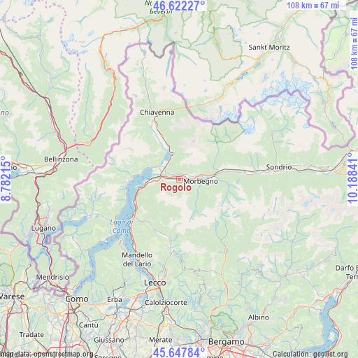
Rogolo GPS coordinates[2]
46° 8' 13.956" North, 9° 29' 7.008" East
| Map corner | latitude | longitude |
|---|---|---|
| Upper-left | 46.62227°, | 8.78215° |
| Center: | 46.13721°, | 9.48528° |
| Lower-right: | 45.64784°, | 10.18841° |
| Map W x H: | 108.3×108.3 km | = 67.3×67.3mi |
| max Lat: | 47.04031° ⇑5.3% North |
| Rogolo: | 46.13721° |
| min Lat: | ⇓94.7% South 35.50142° |
| min Long | Rogolo | max Long |
| 6.69888° | 9.48528° | 18.48682° |
| W 26.5%⇐ | ⇒73.5% E |
Elevation
Elevation of Rogolo is 207 m = 679 ft, and this is 99.7 m = 327 ft below average elevation for this country.
| Max E: |
2085 m = 6841 ft | 54.3% |
| Avg. | 306.7 m = 1006 ft | |
| Rogolo | 207 m = 679 ft | |
Min E: |
-4 m = -13 ft | 45.7% |
See also: Italy elevation on elevation.city.
Geographical zone
Rogolo is located in North temperate zone (between Tropic of Cancer and the Arctic Circle). Distance of this North polar circle is 2271.2 km =1411.3 mi to North.| Distance of | km | miles | from Rogolo |
|---|---|---|---|
| North Pole | 4877.1 | 3030.5 | to North |
| Arctic Circle | 2271.2 | 1411.3 | to North |
| Tropic Cancer | 2524.1 | 1568.4 | to South |
| Equator | 5130 | 3187.6 | to South |


Nearby cities:
15 places around Rogolo: (largest is in red/bold)
• Andalo Valtellino
0.9 km =0.6 mi,  261°
261°
• Bema
6.9 km =4.3 mi,  117°
117°
• Cercino
2.9 km =1.8 mi,  37°
37°
• Cino
2.4 km =1.5 mi,  0°
0°
• Cosio Valtellino
5.1 km =3.2 mi,  92°
92°
• Delebio
1.8 km =1.1 mi,  267°
267°
• Dubino
5.4 km =3.4 mi,  308°
308°
• Mantello
1.7 km =1.1 mi,  9°
9°
• Mello
5.2 km =3.2 mi,  67°
67°
• Morbegno
6.8 km =4.2 mi, 90°
• Piantedo
4.4 km =2.7 mi, 269°
• Piussogno
2.3 km =1.4 mi,  45°
45°
• Rasura
6.6 km =4.1 mi,  128°
128°
• Regoledo
4.7 km =2.9 mi,  95°
95°
• Traona
3.8 km =2.4 mi, 72°
Sources, notices
• [Note1] Compared only with cities in Italy existing in our database
• [Src1] Map data: © OpenStreetMap contributors (CC-BY-SA)
• [Src2] Other city data from geonames.org with taken over terms of usage.
• [Src3] Geographical zone / Annual Mean Temperature by Robert A. Rohde @ Wikipedia
